Tupang geodata
Tupang (Cagayan Valley) is a populated place; located in Philippines in Asia/Manila (GMT+8) time zone. With population of 2,213 people, there are 3861 cities with bigger population in this country. Compared to other cities in Philippines, 98% of cities are located further ↓South; 64.8% of cities are located further →East and 51.1% of cities have lower elevation than Tupang. Note1


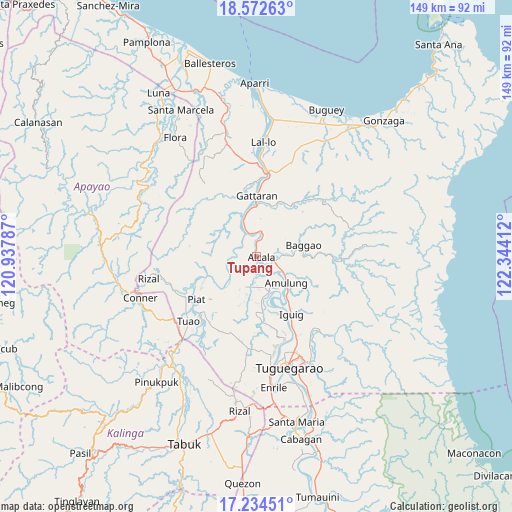
Tupang GPS coordinates[2]
17° 54' 17.388" North, 121° 38' 27.564" East
| Map corner | latitude | longitude |
|---|---|---|
| Upper-left | 18.57263°, | 120.93787° |
| Center: | 17.90483°, | 121.64099° |
| Lower-right: | 17.23451°, | 122.34412° |
| Map W x H: | 148.8×148.8 km | = 92.5×92.5mi |
| max Lat: | 20.78733° ⇑2% North |
| Tupang: | 17.90483° |
| min Lat: | ⇓98% South 4.65442° |
| min Long | Tupang | max Long |
| 117.04868° | 121.64099° | 126.58417° |
| W 35.2%⇐ | ⇒64.8% E |
Elevation
Elevation of Tupang is 24 m = 79 ft, and this is 63.9 m = 210 ft below average elevation for this country.
| Max E: |
2262 m = 7421 ft | 48.9% |
| Avg. | 87.9 m = 288 ft | |
| Tupang | 24 m = 79 ft | |
Min E: |
-2 m = -7 ft | 51.1% |
See also: Philippines elevation on elevation.city.
Geographical zone
Tupang is located in North Torrid zone (between Equator and Tropic of Cancer). Distance of this Northern Tropic circle is 615.1 km =382.2 mi to North.| Distance of | km | miles | from Tupang |
|---|---|---|---|
| North Pole | 8016.2 | 4981 | to North |
| Arctic Circle | 5410.3 | 3361.8 | to North |
| Tropic Cancer | 615.1 | 382.2 | to North |
| Equator | 1990.8 | 1237 | to South |


Nearby cities:
15 places around Tupang: (largest is in red/bold)
• Afusing Centro
6 km =3.7 mi,  194°
194°
• Alannay
18.3 km =11.4 mi,  341°
341°
• Alcala
1.6 km =1 mi,  100°
100°
• Amulung
11.7 km =7.3 mi,  131°
131°
• Calantac
8.7 km =5.4 mi,  86°
86°
• Calaoagan
17.6 km =10.9 mi,  29°
29°
• Dalaoig
9.2 km =5.7 mi,  57°
57°
• Dassun
19.3 km =12 mi,  157°
157°
• Estefania
14.6 km =9.1 mi,  143°
143°
• Gattaran
17.4 km =10.8 mi,  1°
1°
• Lasam
18.3 km =11.4 mi,  346°
346°
• Minanga Norte
18.6 km =11.6 mi,  149°
149°
• Palagao Norte
17.5 km =10.9 mi, 27°
• Santo Niño
7.9 km =4.9 mi,  254°
254°
• Taguing
12.9 km =8 mi,  69°
69°
Sources, notices
• [Note1] Compared only with cities in Philippines existing in our database
• [Src1] Map data: © OpenStreetMap contributors (CC-BY-SA)
• [Src2] Other city data from geonames.org with taken over terms of usage.
• [Src3] Geographical zone / Annual Mean Temperature by Robert A. Rohde @ Wikipedia
