Alcala geodata
Alcala (Cagayan Valley) is a seat of a third-order administrative division; located in Philippines in Asia/Manila (GMT+8) time zone. With population of 4,667 people, there are 1427 cities with bigger population in this country. Compared to other cities in Philippines, 97.9% of cities are located further ↓South; 64.7% of cities are located further →East and 58.1% of cities have lower elevation than Alcala. Note1


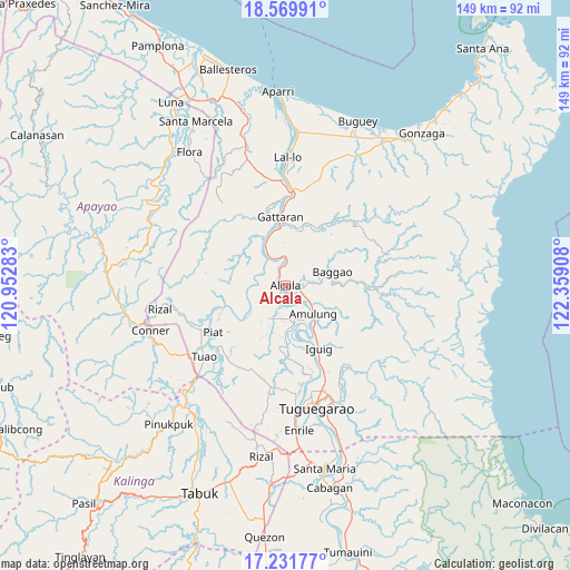
Alcala GPS coordinates[2]
17° 54' 7.56" North, 121° 39' 21.42" East
| Map corner | latitude | longitude |
|---|---|---|
| Upper-left | 18.56991°, | 120.95283° |
| Center: | 17.9021°, | 121.65595° |
| Lower-right: | 17.23177°, | 122.35908° |
| Map W x H: | 148.8×148.8 km | = 92.5×92.5mi |
| max Lat: | 20.78733° ⇑2.1% North |
| Alcala: | 17.9021° |
| min Lat: | ⇓97.9% South 4.65442° |
| min Long | Alcala | max Long |
| 117.04868° | 121.65595° | 126.58417° |
| W 35.3%⇐ | ⇒64.7% E |
Elevation
Elevation of Alcala is 31 m = 102 ft, and this is 56.9 m = 187 ft below average elevation for this country.
| Max E: |
2262 m = 7421 ft | 41.9% |
| Avg. | 87.9 m = 288 ft | |
| Alcala | 31 m = 102 ft | |
Min E: |
-2 m = -7 ft | 58.1% |
See also: Philippines elevation on elevation.city.
Geographical zone
Alcala is located in North Torrid zone (between Equator and Tropic of Cancer). Distance of this Northern Tropic circle is 615.4 km =382.4 mi to North.| Distance of | km | miles | from Alcala |
|---|---|---|---|
| North Pole | 8016.5 | 4981.2 | to North |
| Arctic Circle | 5410.6 | 3362 | to North |
| Tropic Cancer | 615.4 | 382.4 | to North |
| Equator | 1990.5 | 1236.8 | to South |


Nearby cities:
15 places around Alcala: (largest is in red/bold)
• Afusing Centro
6.3 km =3.9 mi,  209°
209°
• Amulung
10.3 km =6.4 mi,  135°
135°
• Calantac
7.1 km =4.4 mi,  83°
83°
• Calaoagan
17.2 km =10.7 mi,  24°
24°
• Dalaoig
8.1 km =5 mi,  49°
49°
• Dassun
18.4 km =11.4 mi,  161°
161°
• Estefania
13.4 km =8.3 mi,  148°
148°
• Gattaran
17.8 km =11.1 mi,  355°
355°
• Iguig
18.9 km =11.7 mi, 153°
• Lasam
19.1 km =11.9 mi,  342°
342°
• Minanga Norte
17.6 km =10.9 mi, 153°
• Palagao Norte
17.1 km =10.6 mi, 22°
• Santo Niño
9.4 km =5.8 mi,  259°
259°
• Taguing
11.6 km =7.2 mi,  64°
64°
• Tupang
1.6 km =1 mi,  280°
280°
Sources, notices
• [Note1] Compared only with cities in Philippines existing in our database
• [Src1] Map data: © OpenStreetMap contributors (CC-BY-SA)
• [Src2] Other city data from geonames.org with taken over terms of usage.
• [Src3] Geographical zone / Annual Mean Temperature by Robert A. Rohde @ Wikipedia
