Tumarbong geodata
Tumarbong (Mimaropa) is a populated place; located in Philippines in Asia/Manila (GMT+8) time zone. With population of 3,261 people, there are 2246 cities with bigger population in this country. Compared to other cities in Philippines, 64.4% of cities are located further ↑North; 98.8% of cities are located further →East and 76.6% of cities have higher elevation than Tumarbong. Note1


Tumarbong GPS coordinates[2]
10° 22' 35.724" North, 119° 27' 28.44" East
| Map corner | latitude | longitude |
|---|---|---|
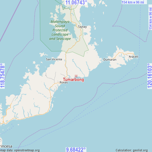
| Upper-left | 11.06743°, | 118.75478° |
| Center: | 10.37659°, | 119.4579° |
| Lower-right: | 9.68422°, | 120.16103° |
| Map W x H: | 153.8×153.8 km | = 95.6×95.6mi |
| max Lat: | 20.78733° ⇑64.4% North |
| Tumarbong: | 10.37659° |
| min Lat: | ⇓35.6% South 4.65442° |
| min Long | Tumarbong | max Long |
| 117.04868° | 119.4579° | 126.58417° |
| W 1.2%⇐ | ⇒98.8% E |
Elevation
Elevation of Tumarbong is 10 m = 33 ft, and this is 77.9 m = 256 ft below average elevation for this country.
| Max E: |
2262 m = 7421 ft | 76.6% |
| Avg. | 87.9 m = 288 ft | |
| Tumarbong | 10 m = 33 ft | |
Min E: |
-2 m = -7 ft | 23.4% |
See also: Philippines elevation on elevation.city.
Geographical zone
Tumarbong is located in North Torrid zone (between Equator and Tropic of Cancer). Distance of Equator is 1153.8 km =716.9 mi to South.| Distance of | km | miles | from Tumarbong |
|---|---|---|---|
| North Pole | 8853.3 | 5501.2 | to North |
| Arctic Circle | 6247.4 | 3882 | to North |
| Tropic Cancer | 1452.2 | 902.4 | to North |
| Equator | 1153.8 | 716.9 | to South |


Nearby cities:
15 places around Tumarbong: (largest is in red/bold)
• Alemanguan
29.8 km =18.5 mi,  331°
331°
• Araceli
61.5 km =38.2 mi,  71°
71°
• Bato
49.9 km =31 mi,  1°
1°
• Calauag
34.7 km =21.6 mi,  20°
20°
• Caramay
32.6 km =20.3 mi,  228°
228°
• Caruray
49.3 km =30.6 mi,  261°
261°
• Dumaran
37.6 km =23.4 mi,  63°
63°
• Guinlo
47.2 km =29.3 mi,  357°
357°
• New Agutaya
26.3 km =16.3 mi,  321°
321°
• Osmeña
53.6 km =33.3 mi, 72°
• Pancol
55.2 km =34.3 mi, 355°
• Port Barton
25.5 km =15.8 mi,  295°
295°
• Roxas
13.8 km =8.6 mi,  243°
243°
• San Vicente
28.1 km =17.5 mi,  307°
307°
• Taytay
49.3 km =30.6 mi,  5°
5°
Sources, notices
• [Note1] Compared only with cities in Philippines existing in our database
• [Src1] Map data: © OpenStreetMap contributors (CC-BY-SA)
• [Src2] Other city data from geonames.org with taken over terms of usage.
• [Src3] Geographical zone / Annual Mean Temperature by Robert A. Rohde @ Wikipedia
