Araceli geodata
Araceli (Mimaropa) is a populated place; located in Philippines in Asia/Manila (GMT+8) time zone. With population of 3,111 people, there are 2409 cities with bigger population in this country. Compared to other cities in Philippines, 62.5% of cities are located further ↑North; 97.1% of cities are located further →East and 92.7% of cities have higher elevation than Araceli. Note1


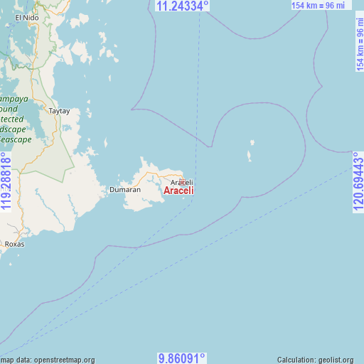
Araceli GPS coordinates[2]
10° 33' 10.44" North, 119° 59' 28.68" East
| Map corner | latitude | longitude |
|---|---|---|
| Upper-left | 11.24334°, | 119.28818° |
| Center: | 10.5529°, | 119.9913° |
| Lower-right: | 9.86091°, | 120.69443° |
| Map W x H: | 153.7×153.7 km | = 95.5×95.5mi |
| max Lat: | 20.78733° ⇑62.5% North |
| Araceli: | 10.5529° |
| min Lat: | ⇓37.5% South 4.65442° |
| min Long | Araceli | max Long |
| 117.04868° | 119.9913° | 126.58417° |
| W 2.9%⇐ | ⇒97.1% E |
Elevation
Elevation of Araceli is 6 m = 20 ft, and this is 81.9 m = 269 ft below average elevation for this country.
| Max E: |
2262 m = 7421 ft | 92.7% |
| Avg. | 87.9 m = 288 ft | |
| Araceli | 6 m = 20 ft | |
Min E: |
-2 m = -7 ft | 7.3% |
See also: Philippines elevation on elevation.city.
Geographical zone
Araceli is located in North Torrid zone (between Equator and Tropic of Cancer). Distance of Equator is 1173.4 km =729.1 mi to South.| Distance of | km | miles | from Araceli |
|---|---|---|---|
| North Pole | 8833.7 | 5489 | to North |
| Arctic Circle | 6227.8 | 3869.8 | to North |
| Tropic Cancer | 1432.5 | 890.1 | to North |
| Equator | 1173.4 | 729.1 | to South |


Nearby cities:
15 places around Araceli: (largest is in red/bold)
• Alemanguan
72.9 km =45.3 mi,  275°
275°
• Bato
64.4 km =40 mi,  298°
298°
• Calauag
47.7 km =29.6 mi,  285°
285°
• Casian
61.6 km =38.3 mi,  330°
330°
• Dumaran
24.7 km =15.3 mi,  262°
262°
• Guinlo
66.4 km =41.3 mi, 294°
• Limanancong
84.4 km =52.4 mi,  305°
305°
• New Agutaya
74.7 km =46.4 mi,  270°
270°
• Osmeña
8 km =5 mi,  243°
243°
• Pancol
72.2 km =44.9 mi, 299°
• Port Barton
81.8 km =50.8 mi, 263°
• Roxas
75.2 km =46.7 mi,  249°
249°
• San Vicente
80.6 km =50.1 mi, 268°
• Taytay
61.4 km =38.2 mi, 298°
• Tumarbong
61.5 km =38.2 mi, 251°
Sources, notices
• [Note1] Compared only with cities in Philippines existing in our database
• [Src1] Map data: © OpenStreetMap contributors (CC-BY-SA)
• [Src2] Other city data from geonames.org with taken over terms of usage.
• [Src3] Geographical zone / Annual Mean Temperature by Robert A. Rohde @ Wikipedia
