New Agutaya geodata
New Agutaya (Mimaropa) is a populated place; located in Philippines in Asia/Manila (GMT+8) time zone. With population of 2,464 people, there are 3357 cities with bigger population in this country. Compared to other cities in Philippines, 62.5% of cities are located further ↑North; 99% of cities are located further →East and 97.1% of cities have higher elevation than New Agutaya. Note1


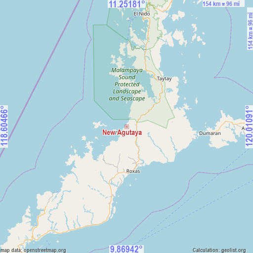
New Agutaya GPS coordinates[2]
10° 33' 41.004" North, 119° 18' 28.008" East
| Map corner | latitude | longitude |
|---|---|---|
| Upper-left | 11.25181°, | 118.60466° |
| Center: | 10.56139°, | 119.30778° |
| Lower-right: | 9.86942°, | 120.01091° |
| Map W x H: | 153.7×153.7 km | = 95.5×95.5mi |
| max Lat: | 20.78733° ⇑62.5% North |
| New Agutaya: | 10.56139° |
| min Lat: | ⇓37.5% South 4.65442° |
| min Long | New Agutaya | max Long |
| 117.04868° | 119.30778° | 126.58417° |
| W 1%⇐ | ⇒99% E |
Elevation
Elevation of New Agutaya is 4 m = 13 ft, and this is 83.9 m = 275 ft below average elevation for this country.
| Max E: |
2262 m = 7421 ft | 97.1% |
| Avg. | 87.9 m = 288 ft | |
| New Agutaya | 4 m = 13 ft | |
Min E: |
-2 m = -7 ft | 2.9% |
See also: Philippines elevation on elevation.city.
Geographical zone
New Agutaya is located in North Torrid zone (between Equator and Tropic of Cancer). Distance of Equator is 1174.3 km =729.7 mi to South.| Distance of | km | miles | from New Agutaya |
|---|---|---|---|
| North Pole | 8832.7 | 5488.4 | to North |
| Arctic Circle | 6226.9 | 3869.2 | to North |
| Tropic Cancer | 1431.6 | 889.6 | to North |
| Equator | 1174.3 | 729.7 | to South |


Nearby cities:
15 places around New Agutaya: (largest is in red/bold)
• Alemanguan
6 km =3.7 mi,  20°
20°
• Bato
34.3 km =21.3 mi,  31°
31°
• Calauag
31.1 km =19.3 mi,  67°
67°
• Caramay
43 km =26.7 mi,  190°
190°
• Caruray
42.7 km =26.5 mi,  229°
229°
• Dumaran
50.4 km =31.3 mi,  94°
94°
• Guinlo
30.2 km =18.8 mi, 28°
• Limanancong
47.9 km =29.8 mi,  6°
6°
• Osmeña
67.7 km =42.1 mi, 93°
• Pancol
36.4 km =22.6 mi, 18°
• Port Barton
11.6 km =7.2 mi,  214°
214°
• Roxas
27 km =16.8 mi,  171°
171°
• San Vicente
6.8 km =4.2 mi,  239°
239°
• Taytay
35.3 km =21.9 mi,  36°
36°
• Tumarbong
26.3 km =16.3 mi,  141°
141°
Sources, notices
• [Note1] Compared only with cities in Philippines existing in our database
• [Src1] Map data: © OpenStreetMap contributors (CC-BY-SA)
• [Src2] Other city data from geonames.org with taken over terms of usage.
• [Src3] Geographical zone / Annual Mean Temperature by Robert A. Rohde @ Wikipedia
