Caramay geodata
Caramay (Mimaropa) is a populated place; located in Philippines in Asia/Manila (GMT+8) time zone. With population of 2,524 people, there are 3251 cities with bigger population in this country. Compared to other cities in Philippines, 66.4% of cities are located further ↑North; 99.1% of cities are located further →East and 92.7% of cities have higher elevation than Caramay. Note1


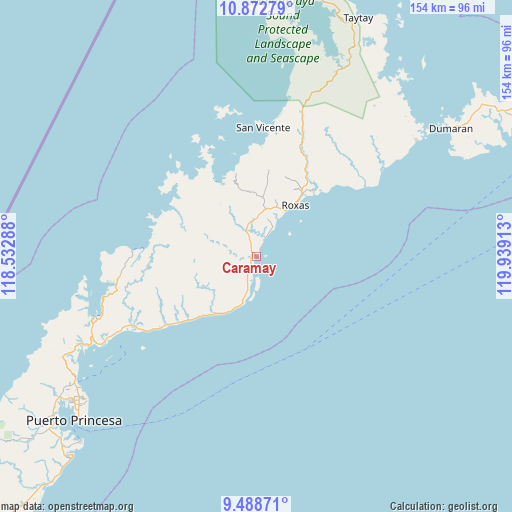
Caramay GPS coordinates[2]
10° 10' 53.4" North, 119° 14' 9.6" East
| Map corner | latitude | longitude |
|---|---|---|
| Upper-left | 10.87279°, | 118.53288° |
| Center: | 10.1815°, | 119.236° |
| Lower-right: | 9.48871°, | 119.93913° |
| Map W x H: | 153.9×153.9 km | = 95.6×95.6mi |
| max Lat: | 20.78733° ⇑66.4% North |
| Caramay: | 10.1815° |
| min Lat: | ⇓33.6% South 4.65442° |
| min Long | Caramay | max Long |
| 117.04868° | 119.236° | 126.58417° |
| W 0.9%⇐ | ⇒99.1% E |
Elevation
Elevation of Caramay is 6 m = 20 ft, and this is 81.9 m = 269 ft below average elevation for this country.
| Max E: |
2262 m = 7421 ft | 92.7% |
| Avg. | 87.9 m = 288 ft | |
| Caramay | 6 m = 20 ft | |
Min E: |
-2 m = -7 ft | 7.3% |
See also: Philippines elevation on elevation.city.
Geographical zone
Caramay is located in North Torrid zone (between Equator and Tropic of Cancer). Distance of Equator is 1132.1 km =703.5 mi to South.| Distance of | km | miles | from Caramay |
|---|---|---|---|
| North Pole | 8875 | 5514.7 | to North |
| Arctic Circle | 6269.1 | 3895.4 | to North |
| Tropic Cancer | 1473.8 | 915.8 | to North |
| Equator | 1132.1 | 703.5 | to South |


Nearby cities:
15 places around Caramay: (largest is in red/bold)
• Alemanguan
48.9 km =30.4 mi,  11°
11°
• Bacungan
65.7 km =40.8 mi,  242°
242°
• Baheli
54 km =33.6 mi,  249°
249°
• Calauag
65.3 km =40.6 mi,  34°
34°
• Caruray
28.3 km =17.6 mi,  300°
300°
• Dumaran
69.5 km =43.2 mi,  56°
56°
• Guinlo
72.3 km =44.9 mi,  17°
17°
• Irahuan
72.6 km =45.1 mi, 235°
• New Agutaya
43 km =26.7 mi, 10°
• Port Barton
32.7 km =20.3 mi,  2°
2°
• Roxas
19.6 km =12.2 mi,  37°
37°
• San Jose
67.4 km =41.9 mi,  231°
231°
• San Vicente
38.8 km =24.1 mi, 2°
• Tagburos
67.7 km =42.1 mi, 234°
• Tumarbong
32.6 km =20.3 mi,  48°
48°
Sources, notices
• [Note1] Compared only with cities in Philippines existing in our database
• [Src1] Map data: © OpenStreetMap contributors (CC-BY-SA)
• [Src2] Other city data from geonames.org with taken over terms of usage.
• [Src3] Geographical zone / Annual Mean Temperature by Robert A. Rohde @ Wikipedia
