Claver geodata
Claver (Caraga) is a seat of a third-order administrative division; located in Philippines in Asia/Manila (GMT+8) time zone. With population of 5,906 people, there are 1069 cities with bigger population in this country. Compared to other cities in Philippines, 72.8% of cities are located further ↑North; 96.1% of cities are located further ←West and 85.4% of cities have higher elevation than Claver. Note1


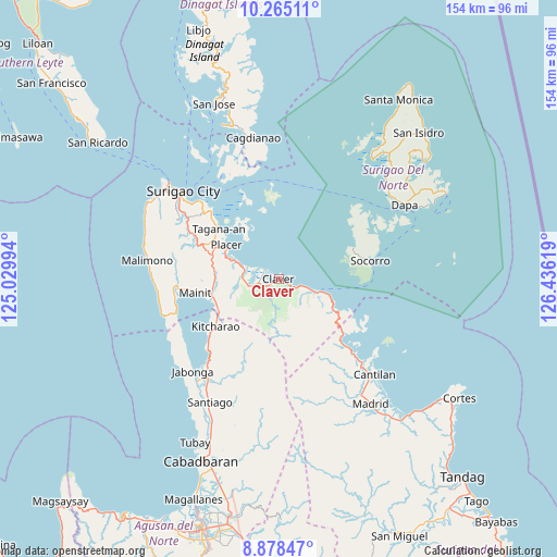
Claver GPS coordinates[2]
9° 34' 21" North, 125° 43' 59.016" East
| Map corner | latitude | longitude |
|---|---|---|
| Upper-left | 10.26511°, | 125.02994° |
| Center: | 9.5725°, | 125.73306° |
| Lower-right: | 8.87847°, | 126.43619° |
| Map W x H: | 154.2×154.2 km | = 95.8×95.8mi |
| max Lat: | 20.78733° ⇑72.8% North |
| Claver: | 9.5725° |
| min Lat: | ⇓27.2% South 4.65442° |
| min Long | Claver | max Long |
| 117.04868° | 125.73306° | 126.58417° |
| W 96.1%⇐ | ⇒3.9% E |
Elevation
Elevation of Claver is 8 m = 26 ft, and this is 79.9 m = 262 ft below average elevation for this country.
| Max E: |
2262 m = 7421 ft | 85.4% |
| Avg. | 87.9 m = 288 ft | |
| Claver | 8 m = 26 ft | |
Min E: |
-2 m = -7 ft | 14.6% |
See also: Philippines elevation on elevation.city.
Geographical zone
Claver is located in North Torrid zone (between Equator and Tropic of Cancer). Distance of Equator is 1064.4 km =661.4 mi to South.| Distance of | km | miles | from Claver |
|---|---|---|---|
| North Pole | 8942.7 | 5556.7 | to North |
| Arctic Circle | 6336.8 | 3937.5 | to North |
| Tropic Cancer | 1541.6 | 957.9 | to North |
| Equator | 1064.4 | 661.4 | to South |


Nearby cities:
15 places around Claver: (largest is in red/bold)
• Adlay
25.6 km =15.9 mi,  135°
135°
• Alegria
20.7 km =12.9 mi,  235°
235°
• Bacuag
11.1 km =6.9 mi,  290°
290°
• Capalayan
27.9 km =17.3 mi,  312°
312°
• Gigaquit
4.6 km =2.9 mi,  302°
302°
• Kitcharao
21.9 km =13.6 mi,  233°
233°
• Luna
31.6 km =19.6 mi, 305°
• Mainit
23.4 km =14.5 mi,  259°
259°
• Placer
17 km =10.6 mi, 302°
• San Francisco
27.6 km =17.1 mi, 259°
• Sison
24.4 km =15.2 mi, 293°
• Socorro
26.2 km =16.3 mi,  78°
78°
• Tagana-an
21.3 km =13.2 mi, 310°
• Talisay
30.3 km =18.8 mi,  334°
334°
• Tubod
17.8 km =11.1 mi,  266°
266°
Sources, notices
• [Note1] Compared only with cities in Philippines existing in our database
• [Src1] Map data: © OpenStreetMap contributors (CC-BY-SA)
• [Src2] Other city data from geonames.org with taken over terms of usage.
• [Src3] Geographical zone / Annual Mean Temperature by Robert A. Rohde @ Wikipedia
