Tuban geodata
Tuban (Mimaropa) is a populated place; located in Philippines in Asia/Manila (GMT+8) time zone. With population of 2,402 people, there are 3457 cities with bigger population in this country. Compared to other cities in Philippines, 56.4% of cities are located further ↓South; 81.5% of cities are located further →East and 67.5% of cities have lower elevation than Tuban. Note1
Administrative division(s):
- Level 1: Mimaropa
- Level 2: Province of Mindoro Occidental
- Level 3: Sablayan


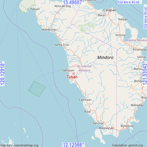
Tuban GPS coordinates[2]
12° 48' 43.92" North, 120° 49' 56.28" East
| Map corner | latitude | longitude |
|---|---|---|
| Upper-left | 13.49687°, | 120.12918° |
| Center: | 12.8122°, | 120.8323° |
| Lower-right: | 12.12566°, | 121.53543° |
| Map W x H: | 152.5×152.5 km | = 94.8×94.8mi |
| max Lat: | 20.78733° ⇑43.6% North |
| Tuban: | 12.8122° |
| min Lat: | ⇓56.4% South 4.65442° |
| min Long | Tuban | max Long |
| 117.04868° | 120.8323° | 126.58417° |
| W 18.5%⇐ | ⇒81.5% E |
Elevation
Elevation of Tuban is 47 m = 154 ft, and this is 40.9 m = 134 ft below average elevation for this country.
| Max E: |
2262 m = 7421 ft | 32.5% |
| Avg. | 87.9 m = 288 ft | |
| Tuban | 47 m = 154 ft | |
Min E: |
-2 m = -7 ft | 67.5% |
See also: Philippines elevation on elevation.city.
Geographical zone
Tuban is located in North Torrid zone (between Equator and Tropic of Cancer). Distance of this Northern Tropic circle is 1181.3 km =734 mi to North.| Distance of | km | miles | from Tuban |
|---|---|---|---|
| North Pole | 8582.5 | 5332.9 | to North |
| Arctic Circle | 5976.6 | 3713.7 | to North |
| Tropic Cancer | 1181.3 | 734 | to North |
| Equator | 1424.6 | 885.2 | to South |


Nearby cities:
15 places around Tuban: (largest is in red/bold)
• Adela
43.9 km =27.3 mi,  159°
159°
• Banos
20.3 km =12.6 mi, 155°
• Barahan
23.5 km =14.6 mi,  341°
341°
• Batasan
7.3 km =4.5 mi,  226°
226°
• Calintaan
29.4 km =18.3 mi, 158°
• Irirum
24.3 km =15.1 mi,  153°
153°
• La Curva
50.9 km =31.6 mi, 152°
• Ligaya
18.1 km =11.2 mi, 158°
• Mamburao
52.4 km =32.6 mi,  330°
330°
• Pitogo
44 km =27.3 mi,  140°
140°
• Rizal
41.1 km =25.5 mi, 159°
• Sablayan
7.3 km =4.5 mi,  289°
289°
• San Agustin
46.8 km =29.1 mi, 158°
• San Pedro
43.6 km =27.1 mi, 153°
• Santa Cruz
31.4 km =19.5 mi, 337°
Sources, notices
• [Note1] Compared only with cities in Philippines existing in our database
• [Src1] Map data: © OpenStreetMap contributors (CC-BY-SA)
• [Src2] Other city data from geonames.org with taken over terms of usage.
• [Src3] Geographical zone / Annual Mean Temperature by Robert A. Rohde @ Wikipedia
