Batasan geodata
Batasan (Mimaropa) is a populated place; located in Philippines in Asia/Manila (GMT+8) time zone. With population of 4,752 people, there are 1394 cities with bigger population in this country. Compared to other cities in Philippines, 56.3% of cities are located further ↓South; 82.7% of cities are located further →East and 73.2% of cities have higher elevation than Batasan. Note1


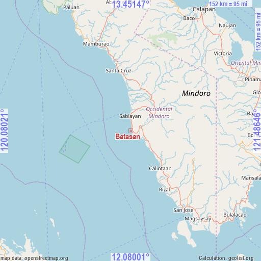
Batasan GPS coordinates[2]
12° 46' 0.012" North, 120° 46' 59.988" East
| Map corner | latitude | longitude |
|---|---|---|
| Upper-left | 13.45147°, | 120.08021° |
| Center: | 12.76667°, | 120.78333° |
| Lower-right: | 12.08001°, | 121.48646° |
| Map W x H: | 152.5×152.5 km | = 94.8×94.8mi |
| max Lat: | 20.78733° ⇑43.7% North |
| Batasan: | 12.76667° |
| min Lat: | ⇓56.3% South 4.65442° |
| min Long | Batasan | max Long |
| 117.04868° | 120.78333° | 126.58417° |
| W 17.3%⇐ | ⇒82.7% E |
Elevation
Elevation of Batasan is 11 m = 36 ft, and this is 76.9 m = 252 ft below average elevation for this country.
| Max E: |
2262 m = 7421 ft | 73.2% |
| Avg. | 87.9 m = 288 ft | |
| Batasan | 11 m = 36 ft | |
Min E: |
-2 m = -7 ft | 26.8% |
See also: Philippines elevation on elevation.city.
Geographical zone
Batasan is located in North Torrid zone (between Equator and Tropic of Cancer). Distance of this Northern Tropic circle is 1186.4 km =737.2 mi to North.| Distance of | km | miles | from Batasan |
|---|---|---|---|
| North Pole | 8587.5 | 5336 | to North |
| Arctic Circle | 5981.7 | 3716.9 | to North |
| Tropic Cancer | 1186.4 | 737.2 | to North |
| Equator | 1419.5 | 882 | to South |


Nearby cities:
15 places around Batasan: (largest is in red/bold)
• Adela
41.6 km =25.8 mi,  150°
150°
• Banos
19.2 km =11.9 mi,  134°
134°
• Barahan
27.4 km =17 mi,  355°
355°
• Calintaan
27.6 km =17.1 mi,  143°
143°
• Irirum
23.1 km =14.4 mi, 136°
• La Curva
49.3 km =30.6 mi, 144°
• Ligaya
16.8 km =10.4 mi, 135°
• Magbay
51.8 km =32.2 mi, 139°
• Pitogo
44.1 km =27.4 mi, 130°
• Rizal
38.8 km =24.1 mi, 149°
• Sablayan
7.7 km =4.8 mi,  348°
348°
• San Agustin
44.6 km =27.7 mi, 149°
• San Pedro
42 km =26.1 mi, 144°
• Santa Cruz
34.8 km =21.6 mi, 349°
• Tuban
7.3 km =4.5 mi,  46°
46°
Sources, notices
• [Note1] Compared only with cities in Philippines existing in our database
• [Src1] Map data: © OpenStreetMap contributors (CC-BY-SA)
• [Src2] Other city data from geonames.org with taken over terms of usage.
• [Src3] Geographical zone / Annual Mean Temperature by Robert A. Rohde @ Wikipedia
