Banos geodata
Banos (Mimaropa) is a populated place; located in Philippines in Asia/Manila (GMT+8) time zone. With population of 2,340 people, there are 3582 cities with bigger population in this country. Compared to other cities in Philippines, 55.9% of cities are located further ↓South; 79% of cities are located further →East and 70.2% of cities have higher elevation than Banos. Note1
Administrative division(s):
- Level 1: Mimaropa
- Level 2: Province of Mindoro Occidental
- Level 3: Calintaan


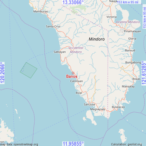
Banos GPS coordinates[2]
12° 38' 43.908" North, 120° 54' 34.992" East
| Map corner | latitude | longitude |
|---|---|---|
| Upper-left | 13.33066°, | 120.2066° |
| Center: | 12.64553°, | 120.90972° |
| Lower-right: | 11.95855°, | 121.61285° |
| Map W x H: | 152.6×152.6 km | = 94.8×94.8mi |
| max Lat: | 20.78733° ⇑44.1% North |
| Banos: | 12.64553° |
| min Lat: | ⇓55.9% South 4.65442° |
| min Long | Banos | max Long |
| 117.04868° | 120.90972° | 126.58417° |
| W 21%⇐ | ⇒79% E |
Elevation
Elevation of Banos is 12 m = 39 ft, and this is 75.9 m = 249 ft below average elevation for this country.
| Max E: |
2262 m = 7421 ft | 70.2% |
| Avg. | 87.9 m = 288 ft | |
| Banos | 12 m = 39 ft | |
Min E: |
-2 m = -7 ft | 29.8% |
See also: Philippines elevation on elevation.city.
Geographical zone
Banos is located in North Torrid zone (between Equator and Tropic of Cancer). Distance of this Northern Tropic circle is 1199.9 km =745.6 mi to North.| Distance of | km | miles | from Banos |
|---|---|---|---|
| North Pole | 8601 | 5344.4 | to North |
| Arctic Circle | 5995.1 | 3725.2 | to North |
| Tropic Cancer | 1199.9 | 745.6 | to North |
| Equator | 1406.1 | 873.7 | to South |


Nearby cities:
15 places around Banos: (largest is in red/bold)
• Adela
23.7 km =14.7 mi,  163°
163°
• Babug
33.5 km =20.8 mi,  154°
154°
• Bagong Sikat
35 km =21.7 mi, 151°
• Batasan
19.2 km =11.9 mi,  314°
314°
• Calintaan
9.1 km =5.7 mi, 163°
• Irirum
4 km =2.5 mi, 145°
• La Curva
30.6 km =19 mi, 151°
• Ligaya
2.5 km =1.6 mi, 310°
• Magbay
32.7 km =20.3 mi,  143°
143°
• Pitogo
24.9 km =15.5 mi,  128°
128°
• Rizal
20.8 km =12.9 mi, 162°
• Sablayan
26 km =16.2 mi,  324°
324°
• San Agustin
26.5 km =16.5 mi, 161°
• San Pedro
23.3 km =14.5 mi, 151°
• Tuban
20.3 km =12.6 mi,  335°
335°
Sources, notices
• [Note1] Compared only with cities in Philippines existing in our database
• [Src1] Map data: © OpenStreetMap contributors (CC-BY-SA)
• [Src2] Other city data from geonames.org with taken over terms of usage.
• [Src3] Geographical zone / Annual Mean Temperature by Robert A. Rohde @ Wikipedia
