Santa Cruz geodata
Santa Cruz (Mimaropa) is a populated place; located in Philippines in Asia/Manila (GMT+8) time zone. With population of 9,826 people, there are 620 cities with bigger population in this country. Compared to other cities in Philippines, 58% of cities are located further ↓South; 84.3% of cities are located further →East and 85.4% of cities have higher elevation than Santa Cruz. Note1
Administrative division(s):
- Level 1: Mimaropa
- Level 2: Province of Mindoro Occidental
- Level 3: Santa Cruz


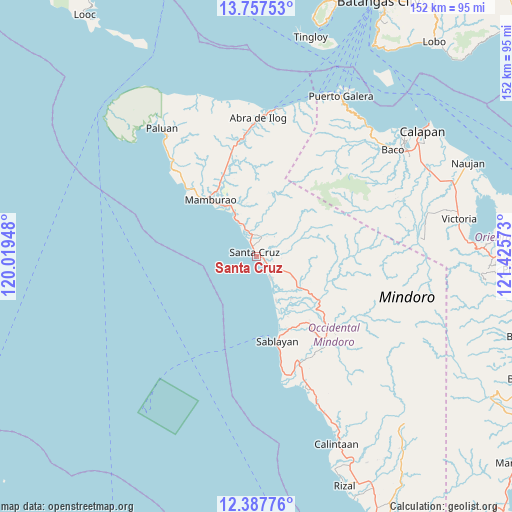
Santa Cruz GPS coordinates[2]
13° 4' 24.96" North, 120° 43' 21.36" East
| Map corner | latitude | longitude |
|---|---|---|
| Upper-left | 13.75753°, | 120.01948° |
| Center: | 13.0736°, | 120.7226° |
| Lower-right: | 12.38776°, | 121.42573° |
| Map W x H: | 152.3×152.3 km | = 94.6×94.6mi |
| max Lat: | 20.78733° ⇑42% North |
| Santa Cruz: | 13.0736° |
| min Lat: | ⇓58% South 4.65442° |
| min Long | Santa Cruz | max Long |
| 117.04868° | 120.7226° | 126.58417° |
| W 15.7%⇐ | ⇒84.3% E |
Elevation
Elevation of Santa Cruz is 8 m = 26 ft, and this is 79.9 m = 262 ft below average elevation for this country.
| Max E: |
2262 m = 7421 ft | 85.4% |
| Avg. | 87.9 m = 288 ft | |
| Santa Cruz | 8 m = 26 ft | |
Min E: |
-2 m = -7 ft | 14.6% |
See also: Philippines elevation on elevation.city.
Geographical zone
Santa Cruz is located in North Torrid zone (between Equator and Tropic of Cancer). Distance of this Northern Tropic circle is 1152.3 km =716 mi to North.| Distance of | km | miles | from Santa Cruz |
|---|---|---|---|
| North Pole | 8553.4 | 5314.8 | to North |
| Arctic Circle | 5947.5 | 3695.6 | to North |
| Tropic Cancer | 1152.3 | 716 | to North |
| Equator | 1453.6 | 903.2 | to South |


Nearby cities:
15 places around Santa Cruz: (largest is in red/bold)
• Abra de Ilog
41.2 km =25.6 mi,  0°
0°
• Aurora
46.5 km =28.9 mi,  67°
67°
• Barahan
8.1 km =5 mi,  148°
148°
• Batasan
34.8 km =21.6 mi,  169°
169°
• Cabacao
29.9 km =18.6 mi,  346°
346°
• Communal
49.1 km =30.5 mi, 65°
• Dulangan
49.5 km =30.8 mi,  58°
58°
• Ligaya
49.5 km =30.8 mi,  158°
158°
• Mamburao
21.6 km =13.4 mi,  320°
320°
• Odala
46.2 km =28.7 mi,  13°
13°
• Paluan
47.4 km =29.5 mi, 323°
• Sablayan
27 km =16.8 mi, 169°
• Tayaman
23.8 km =14.8 mi, 316°
• Tuban
31.4 km =19.5 mi, 157°
• Wawa
43.4 km =27 mi, 3°
Sources, notices
• [Note1] Compared only with cities in Philippines existing in our database
• [Src1] Map data: © OpenStreetMap contributors (CC-BY-SA)
• [Src2] Other city data from geonames.org with taken over terms of usage.
• [Src3] Geographical zone / Annual Mean Temperature by Robert A. Rohde @ Wikipedia
