Lumil geodata
Lumil (Calabarzon) is a populated place; located in Philippines in Asia/Manila (GMT+8) time zone. With population of 2,512 people, there are 3262 cities with bigger population in this country. Compared to other cities in Philippines, 71.5% of cities are located further ↓South; 76.1% of cities are located further →East and 94.2% of cities have lower elevation than Lumil. Note1


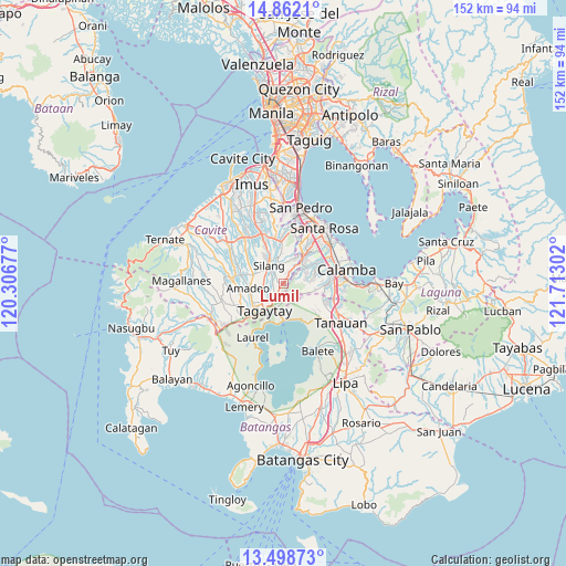
Lumil GPS coordinates[2]
14° 10' 53.184" North, 121° 0' 35.604" East
| Map corner | latitude | longitude |
|---|---|---|
| Upper-left | 14.8621°, | 120.30677° |
| Center: | 14.18144°, | 121.00989° |
| Lower-right: | 13.49873°, | 121.71302° |
| Map W x H: | 151.6×151.6 km | = 94.2×94.2mi |
| max Lat: | 20.78733° ⇑28.5% North |
| Lumil: | 14.18144° |
| min Lat: | ⇓71.5% South 4.65442° |
| min Long | Lumil | max Long |
| 117.04868° | 121.00989° | 126.58417° |
| W 23.9%⇐ | ⇒76.1% E |
Elevation
Elevation of Lumil is 381 m = 1250 ft, and this is 293.1 m = 962 ft above average elevation for this country.
| Max E: |
2262 m = 7421 ft | 5.8% |
| Lumil | 381 m 1250 ft | |
| Avg. | 87.9 m = 288 ft | |
Min E: |
-2 m = -7 ft | 94.2% |
See also: Philippines elevation on elevation.city.
Geographical zone
Lumil is located in North Torrid zone (between Equator and Tropic of Cancer). Distance of this Northern Tropic circle is 1029.1 km =639.5 mi to North.| Distance of | km | miles | from Lumil |
|---|---|---|---|
| North Pole | 8430.2 | 5238.3 | to North |
| Arctic Circle | 5824.3 | 3619.1 | to North |
| Tropic Cancer | 1029.1 | 639.5 | to North |
| Equator | 1576.8 | 979.8 | to South |


Nearby cities:
15 places around Lumil: (largest is in red/bold)
• Amadeo
9.4 km =5.8 mi,  262°
262°
• Ambulong
11.8 km =7.3 mi,  151°
151°
• Balite Segundo
3.8 km =2.4 mi,  272°
272°
• Biga
9.4 km =5.8 mi,  334°
334°
• Bilog-Bilog
11.4 km =7.1 mi,  131°
131°
• Bulihan
10.9 km =6.8 mi,  351°
351°
• Maguyam
9.1 km =5.7 mi,  356°
356°
• Malabag
5.6 km =3.5 mi,  238°
238°
• Pangil
11.2 km =7 mi,  281°
281°
• Patuto
8.6 km =5.3 mi,  212°
212°
• Puting Kahoy
4.4 km =2.7 mi,  30°
30°
• Sampaloc
11.2 km =7 mi,  201°
201°
• Silang
5.6 km =3.5 mi,  312°
312°
• Talisay
10 km =6.2 mi,  172°
172°
• Tranca
8.7 km =5.4 mi,  143°
143°
Sources, notices
• [Note1] Compared only with cities in Philippines existing in our database
• [Src1] Map data: © OpenStreetMap contributors (CC-BY-SA)
• [Src2] Other city data from geonames.org with taken over terms of usage.
• [Src3] Geographical zone / Annual Mean Temperature by Robert A. Rohde @ Wikipedia
