Talisay geodata
Talisay (Calabarzon) is a seat of a third-order administrative division; located in Philippines in Asia/Manila (GMT+8) time zone. With population of 24,969 people, there are 321 cities with bigger population in this country. Compared to other cities in Philippines, 70.2% of cities are located further ↓South; 75.8% of cities are located further →East and 59.2% of cities have higher elevation than Talisay. Note1


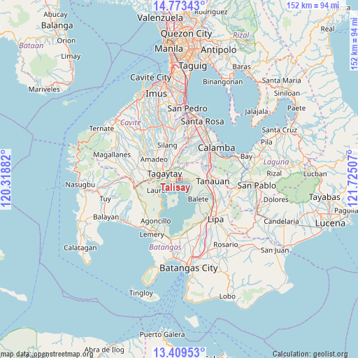
Talisay GPS coordinates[2]
14° 5' 33" North, 121° 1' 18.984" East
| Map corner | latitude | longitude |
|---|---|---|
| Upper-left | 14.77343°, | 120.31882° |
| Center: | 14.0925°, | 121.02194° |
| Lower-right: | 13.40953°, | 121.72507° |
| Map W x H: | 151.7×151.7 km | = 94.3×94.3mi |
| max Lat: | 20.78733° ⇑29.8% North |
| Talisay: | 14.0925° |
| min Lat: | ⇓70.2% South 4.65442° |
| min Long | Talisay | max Long |
| 117.04868° | 121.02194° | 126.58417° |
| W 24.2%⇐ | ⇒75.8% E |
Elevation
Elevation of Talisay is 17 m = 56 ft, and this is 70.9 m = 233 ft below average elevation for this country.
| Max E: |
2262 m = 7421 ft | 59.2% |
| Avg. | 87.9 m = 288 ft | |
| Talisay | 17 m = 56 ft | |
Min E: |
-2 m = -7 ft | 40.8% |
See also: Philippines elevation on elevation.city.
Geographical zone
Talisay is located in North Torrid zone (between Equator and Tropic of Cancer). Distance of this Northern Tropic circle is 1039 km =645.6 mi to North.| Distance of | km | miles | from Talisay |
|---|---|---|---|
| North Pole | 8440.1 | 5244.4 | to North |
| Arctic Circle | 5834.2 | 3625.2 | to North |
| Tropic Cancer | 1039 | 645.6 | to North |
| Equator | 1566.9 | 973.6 | to South |


Nearby cities:
15 places around Talisay: (largest is in red/bold)
• Ambulong
4.3 km =2.7 mi,  96°
96°
• Balele
8.3 km =5.2 mi,  111°
111°
• Balete
11.3 km =7 mi,  135°
135°
• Bilog-Bilog
7.6 km =4.7 mi,  71°
71°
• Boot
7.9 km =4.9 mi,  131°
131°
• Bugaan
11 km =6.8 mi,  237°
237°
• Janopol
7.9 km =4.9 mi, 95°
• Lumil
10 km =6.2 mi,  352°
352°
• Malabag
9.3 km =5.8 mi,  318°
318°
• Pantay Na Matanda
11 km =6.8 mi,  75°
75°
• Patuto
6.5 km =4 mi,  294°
294°
• Sampaloc
5.5 km =3.4 mi,  264°
264°
• Santor
9.4 km =5.8 mi,  87°
87°
• Tagaytay
9.5 km =5.9 mi,  271°
271°
• Tranca
4.8 km =3 mi,  53°
53°
Sources, notices
• [Note1] Compared only with cities in Philippines existing in our database
• [Src1] Map data: © OpenStreetMap contributors (CC-BY-SA)
• [Src2] Other city data from geonames.org with taken over terms of usage.
• [Src3] Geographical zone / Annual Mean Temperature by Robert A. Rohde @ Wikipedia
