Malabag geodata
Malabag (Calabarzon) is a populated place; located in Philippines in Asia/Manila (GMT+8) time zone. With population of 7,021 people, there are 891 cities with bigger population in this country. Compared to other cities in Philippines, 71.2% of cities are located further ↓South; 77.3% of cities are located further →East and 95.9% of cities have lower elevation than Malabag. Note1


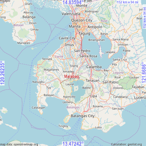
Malabag GPS coordinates[2]
14° 9' 18.72" North, 120° 57' 55.692" East
| Map corner | latitude | longitude |
|---|---|---|
| Upper-left | 14.83594°, | 120.26235° |
| Center: | 14.1552°, | 120.96547° |
| Lower-right: | 13.47242°, | 121.6686° |
| Map W x H: | 151.6×151.6 km | = 94.2×94.2mi |
| max Lat: | 20.78733° ⇑28.8% North |
| Malabag: | 14.1552° |
| min Lat: | ⇓71.2% South 4.65442° |
| min Long | Malabag | max Long |
| 117.04868° | 120.96547° | 126.58417° |
| W 22.7%⇐ | ⇒77.3% E |
Elevation
Elevation of Malabag is 493 m = 1617 ft, and this is 405.1 m = 1329 ft above average elevation for this country.
| Max E: |
2262 m = 7421 ft | 4.1% |
| Malabag | 493 m 1617 ft | |
| Avg. | 87.9 m = 288 ft | |
Min E: |
-2 m = -7 ft | 95.9% |
See also: Philippines elevation on elevation.city.
Geographical zone
Malabag is located in North Torrid zone (between Equator and Tropic of Cancer). Distance of this Northern Tropic circle is 1032 km =641.3 mi to North.| Distance of | km | miles | from Malabag |
|---|---|---|---|
| North Pole | 8433.2 | 5240.1 | to North |
| Arctic Circle | 5827.3 | 3620.9 | to North |
| Tropic Cancer | 1032 | 641.3 | to North |
| Equator | 1573.9 | 978 | to South |


Nearby cities:
15 places around Malabag: (largest is in red/bold)
• Amadeo
4.8 km =3 mi,  290°
290°
• Anuling
8.6 km =5.3 mi,  246°
246°
• Balite Segundo
3.3 km =2.1 mi,  17°
17°
• Indang
10.5 km =6.5 mi,  295°
295°
• Luksuhin
11.2 km =7 mi,  234°
234°
• Lumil
5.6 km =3.5 mi,  58°
58°
• Mendez-Nuñez
7.1 km =4.4 mi, 245°
• Pangil
8 km =5 mi,  309°
309°
• Patuto
4.3 km =2.7 mi,  178°
178°
• Puting Kahoy
9.8 km =6.1 mi,  46°
46°
• Sampaloc
7.5 km =4.7 mi, 175°
• Silang
6.8 km =4.2 mi,  5°
5°
• Tagaytay
7.5 km =4.7 mi,  207°
207°
• Talisay
9.3 km =5.8 mi,  138°
138°
• Tranca
10.7 km =6.6 mi,  112°
112°
Sources, notices
• [Note1] Compared only with cities in Philippines existing in our database
• [Src1] Map data: © OpenStreetMap contributors (CC-BY-SA)
• [Src2] Other city data from geonames.org with taken over terms of usage.
• [Src3] Geographical zone / Annual Mean Temperature by Robert A. Rohde @ Wikipedia
