Tacloban geodata
Tacloban (Eastern Visayas) is a seat of a second-order administrative division; located in Philippines in Asia/Manila (GMT+8) time zone. With population of 242,089 people, there are 40 cities with bigger population in this country. Compared to other cities in Philippines, 54% of cities are located further ↑North; 87.7% of cities are located further ←West and 89.7% of cities have higher elevation than Tacloban. Note1
Administrative division(s):
- Level 1: Eastern Visayas
- Level 2: Province of Leyte
- Level 3: Tacloban City


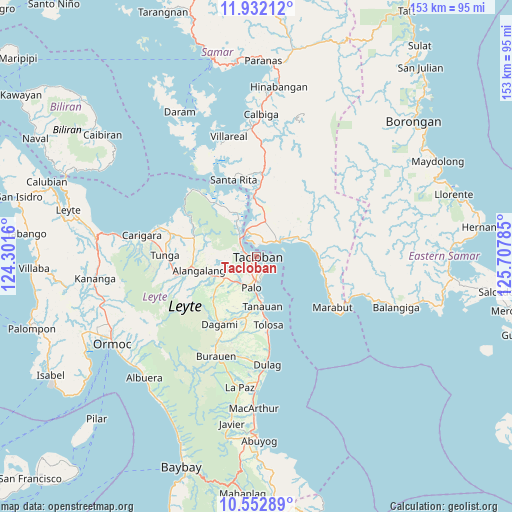
Tacloban GPS coordinates[2]
11° 14' 35.988" North, 125° 0' 16.992" East
| Map corner | latitude | longitude |
|---|---|---|
| Upper-left | 11.93212°, | 124.3016° |
| Center: | 11.24333°, | 125.00472° |
| Lower-right: | 10.55289°, | 125.70785° |
| Map W x H: | 153.4×153.4 km | = 95.3×95.3mi |
| max Lat: | 20.78733° ⇑54% North |
| Tacloban: | 11.24333° |
| min Lat: | ⇓46% South 4.65442° |
| min Long | Tacloban | max Long |
| 117.04868° | 125.00472° | 126.58417° |
| W 87.7%⇐ | ⇒12.3% E |
Elevation
Elevation of Tacloban is 7 m = 23 ft, and this is 80.9 m = 265 ft below average elevation for this country.
| Max E: |
2262 m = 7421 ft | 89.7% |
| Avg. | 87.9 m = 288 ft | |
| Tacloban | 7 m = 23 ft | |
Min E: |
-2 m = -7 ft | 10.3% |
See also: Tacloban elevation on elevation.city.
Geographical zone
Tacloban is located in North Torrid zone (between Equator and Tropic of Cancer). Distance of Equator is 1250.1 km =776.8 mi to South.| Distance of | km | miles | from Tacloban |
|---|---|---|---|
| North Pole | 8756.9 | 5441.3 | to North |
| Arctic Circle | 6151 | 3822.1 | to North |
| Tropic Cancer | 1355.8 | 842.5 | to North |
| Equator | 1250.1 | 776.8 | to South |


Nearby cities:
15 places around Tacloban: (largest is in red/bold)
• Alangalang
17.7 km =11 mi,  256°
256°
• Baras
6.8 km =4.2 mi,  168°
168°
• Basey
8.3 km =5.2 mi,  58°
58°
• Bislig
19.3 km =12 mi, 170°
• Guirang
17 km =10.6 mi,  45°
45°
• Kabuynan
18.2 km =11.3 mi, 173°
• Palo
9.7 km =6 mi,  189°
189°
• Panalanoy
0.9 km =0.6 mi,  11°
11°
• Pastrana
17.6 km =10.9 mi,  227°
227°
• Pawing
7 km =4.3 mi,  181°
181°
• San Antonio
3.8 km =2.4 mi, 11°
• San Miguel
19 km =11.8 mi,  278°
278°
• Santa Fe
11.6 km =7.2 mi,  236°
236°
• Tanauan
14.9 km =9.3 mi, 175°
• Tolosa
16 km =9.9 mi, 175°
Sources, notices
• [Note1] Compared only with cities in Philippines existing in our database
• [Src1] Map data: © OpenStreetMap contributors (CC-BY-SA)
• [Src2] Other city data from geonames.org with taken over terms of usage.
• [Src3] Geographical zone / Annual Mean Temperature by Robert A. Rohde @ Wikipedia
