Pastrana geodata
Pastrana (Eastern Visayas) is a seat of a third-order administrative division; located in Philippines in Asia/Manila (GMT+8) time zone. With population of 2,730 people, there are 2892 cities with bigger population in this country. Compared to other cities in Philippines, 55.4% of cities are located further ↑North; 86% of cities are located further ←West and 63.6% of cities have lower elevation than Pastrana. Note1


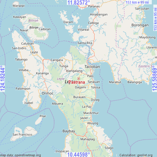
Pastrana GPS coordinates[2]
11° 8' 12.012" North, 124° 53' 8.016" East
| Map corner | latitude | longitude |
|---|---|---|
| Upper-left | 11.82572°, | 124.18244° |
| Center: | 11.13667°, | 124.88556° |
| Lower-right: | 10.44598°, | 125.58869° |
| Map W x H: | 153.4×153.4 km | = 95.3×95.3mi |
| max Lat: | 20.78733° ⇑55.4% North |
| Pastrana: | 11.13667° |
| min Lat: | ⇓44.6% South 4.65442° |
| min Long | Pastrana | max Long |
| 117.04868° | 124.88556° | 126.58417° |
| W 86%⇐ | ⇒14% E |
Elevation
Elevation of Pastrana is 39 m = 128 ft, and this is 48.9 m = 160 ft below average elevation for this country.
| Max E: |
2262 m = 7421 ft | 36.4% |
| Avg. | 87.9 m = 288 ft | |
| Pastrana | 39 m = 128 ft | |
Min E: |
-2 m = -7 ft | 63.6% |
See also: Philippines elevation on elevation.city.
Geographical zone
Pastrana is located in North Torrid zone (between Equator and Tropic of Cancer). Distance of Equator is 1238.3 km =769.4 mi to South.| Distance of | km | miles | from Pastrana |
|---|---|---|---|
| North Pole | 8768.8 | 5448.7 | to North |
| Arctic Circle | 6162.9 | 3829.4 | to North |
| Tropic Cancer | 1367.6 | 849.8 | to North |
| Equator | 1238.3 | 769.4 | to South |


Nearby cities:
15 places around Pastrana: (largest is in red/bold)
• Alangalang
8.8 km =5.5 mi,  331°
331°
• Baras
15.2 km =9.4 mi,  70°
70°
• Canhandugan
11.5 km =7.1 mi,  269°
269°
• Dagami
8.6 km =5.3 mi,  167°
167°
• Jaro
12.4 km =7.7 mi,  295°
295°
• Kabuynan
16.4 km =10.2 mi,  112°
112°
• Palo
11.7 km =7.3 mi,  78°
78°
• Pawing
13.7 km =8.5 mi, 69°
• San Miguel
15.6 km =9.7 mi,  338°
338°
• San Roque
17.2 km =10.7 mi,  123°
123°
• Santa Fe
6.4 km =4 mi,  31°
31°
• Tabontabon
13.5 km =8.4 mi,  142°
142°
• Tacloban
17.6 km =10.9 mi,  47°
47°
• Tanauan
14.5 km =9 mi,  102°
102°
• Tolosa
14.9 km =9.3 mi, 105°
Sources, notices
• [Note1] Compared only with cities in Philippines existing in our database
• [Src1] Map data: © OpenStreetMap contributors (CC-BY-SA)
• [Src2] Other city data from geonames.org with taken over terms of usage.
• [Src3] Geographical zone / Annual Mean Temperature by Robert A. Rohde @ Wikipedia
