Alangalang geodata
Alangalang (Eastern Visayas) is a seat of a third-order administrative division; located in Philippines in Asia/Manila (GMT+8) time zone. With population of 8,096 people, there are 763 cities with bigger population in this country. Compared to other cities in Philippines, 54.5% of cities are located further ↑North; 85.3% of cities are located further ←West and 66.7% of cities have lower elevation than Alangalang. Note1


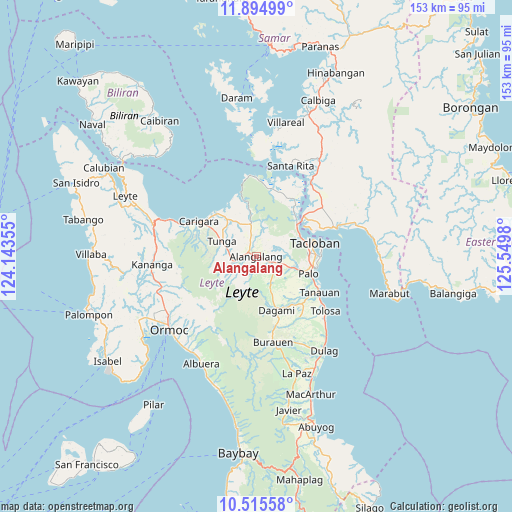
Alangalang GPS coordinates[2]
11° 12' 21.996" North, 124° 50' 48.012" East
| Map corner | latitude | longitude |
|---|---|---|
| Upper-left | 11.89499°, | 124.14355° |
| Center: | 11.20611°, | 124.84667° |
| Lower-right: | 10.51558°, | 125.5498° |
| Map W x H: | 153.4×153.4 km | = 95.3×95.3mi |
| max Lat: | 20.78733° ⇑54.5% North |
| Alangalang: | 11.20611° |
| min Lat: | ⇓45.5% South 4.65442° |
| min Long | Alangalang | max Long |
| 117.04868° | 124.84667° | 126.58417° |
| W 85.3%⇐ | ⇒14.7% E |
Elevation
Elevation of Alangalang is 45 m = 148 ft, and this is 42.9 m = 141 ft below average elevation for this country.
| Max E: |
2262 m = 7421 ft | 33.3% |
| Avg. | 87.9 m = 288 ft | |
| Alangalang | 45 m = 148 ft | |
Min E: |
-2 m = -7 ft | 66.7% |
See also: Philippines elevation on elevation.city.
Geographical zone
Alangalang is located in North Torrid zone (between Equator and Tropic of Cancer). Distance of Equator is 1246 km =774.2 mi to South.| Distance of | km | miles | from Alangalang |
|---|---|---|---|
| North Pole | 8761.1 | 5443.9 | to North |
| Arctic Circle | 6155.2 | 3824.7 | to North |
| Tropic Cancer | 1359.9 | 845 | to North |
| Equator | 1246 | 774.2 | to South |


Nearby cities:
15 places around Alangalang: (largest is in red/bold)
• Baras
18.7 km =11.6 mi,  97°
97°
• Barugo
17.7 km =11 mi,  318°
318°
• Canhandugan
10.8 km =6.7 mi,  222°
222°
• Dagami
17.3 km =10.7 mi,  159°
159°
• Guindapunan
18.7 km =11.6 mi,  304°
304°
• Jaro
7.4 km =4.6 mi,  250°
250°
• Palo
16.6 km =10.3 mi,  108°
108°
• Panalanoy
18.1 km =11.2 mi,  73°
73°
• Pastrana
8.8 km =5.5 mi,  151°
151°
• Pawing
17.3 km =10.7 mi, 99°
• San Antonio
19.6 km =12.2 mi, 66°
• San Miguel
7 km =4.3 mi,  347°
347°
• Santa Fe
7.9 km =4.9 mi, 106°
• Tacloban
17.7 km =11 mi,  76°
76°
• Tunga
11.3 km =7 mi,  292°
292°
Sources, notices
• [Note1] Compared only with cities in Philippines existing in our database
• [Src1] Map data: © OpenStreetMap contributors (CC-BY-SA)
• [Src2] Other city data from geonames.org with taken over terms of usage.
• [Src3] Geographical zone / Annual Mean Temperature by Robert A. Rohde @ Wikipedia
