San Miguel geodata
San Miguel (Eastern Visayas) is a seat of a third-order administrative division; located in Philippines in Asia/Manila (GMT+8) time zone. With population of 3,401 people, there are 2131 cities with bigger population in this country. Compared to other cities in Philippines, 53.6% of cities are located further ↑North; 85.1% of cities are located further ←West and 51.8% of cities have higher elevation than San Miguel. Note1


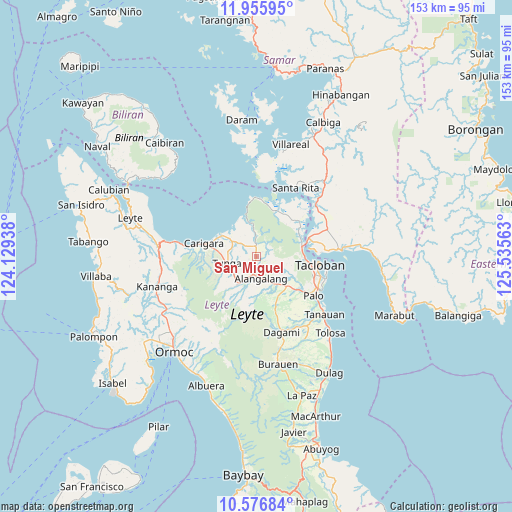
San Miguel GPS coordinates[2]
11° 16' 1.992" North, 124° 49' 57" East
| Map corner | latitude | longitude |
|---|---|---|
| Upper-left | 11.95595°, | 124.12938° |
| Center: | 11.26722°, | 124.8325° |
| Lower-right: | 10.57684°, | 125.53563° |
| Map W x H: | 153.3×153.3 km | = 95.3×95.3mi |
| max Lat: | 20.78733° ⇑53.6% North |
| San Miguel: | 11.26722° |
| min Lat: | ⇓46.4% South 4.65442° |
| min Long | San Miguel | max Long |
| 117.04868° | 124.8325° | 126.58417° |
| W 85.1%⇐ | ⇒14.9% E |
Elevation
Elevation of San Miguel is 22 m = 72 ft, and this is 65.9 m = 216 ft below average elevation for this country.
| Max E: |
2262 m = 7421 ft | 51.8% |
| Avg. | 87.9 m = 288 ft | |
| San Miguel | 22 m = 72 ft | |
Min E: |
-2 m = -7 ft | 48.2% |
See also: Philippines elevation on elevation.city.
Geographical zone
San Miguel is located in North Torrid zone (between Equator and Tropic of Cancer). Distance of Equator is 1252.8 km =778.5 mi to South.| Distance of | km | miles | from San Miguel |
|---|---|---|---|
| North Pole | 8754.3 | 5439.7 | to North |
| Arctic Circle | 6148.4 | 3820.4 | to North |
| Tropic Cancer | 1353.1 | 840.8 | to North |
| Equator | 1252.8 | 778.5 | to South |


Nearby cities:
15 places around San Miguel: (largest is in red/bold)
• Alangalang
7 km =4.3 mi,  167°
167°
• Babatngon
17.5 km =10.9 mi,  4°
4°
• Barugo
12.1 km =7.5 mi,  301°
301°
• Canhandugan
15.8 km =9.8 mi,  201°
201°
• Capoocan
21 km =13 mi,  277°
277°
• Carigara
17.1 km =10.6 mi, 281°
• Guindapunan
14.4 km =8.9 mi,  285°
285°
• Jaro
10.8 km =6.7 mi,  210°
210°
• Panalanoy
19 km =11.8 mi,  95°
95°
• Pastrana
15.6 km =9.7 mi,  158°
158°
• Pawing
21 km =13 mi,  117°
117°
• San Antonio
19.5 km =12.1 mi,  86°
86°
• Santa Fe
12.9 km =8 mi,  134°
134°
• Tacloban
19 km =11.8 mi, 98°
• Tunga
9.1 km =5.7 mi,  254°
254°
Sources, notices
• [Note1] Compared only with cities in Philippines existing in our database
• [Src1] Map data: © OpenStreetMap contributors (CC-BY-SA)
• [Src2] Other city data from geonames.org with taken over terms of usage.
• [Src3] Geographical zone / Annual Mean Temperature by Robert A. Rohde @ Wikipedia
