Santa Fe geodata
Santa Fe (Eastern Visayas) is a seat of a third-order administrative division; located in Philippines in Asia/Manila (GMT+8) time zone. With population of 3,010 people, there are 2517 cities with bigger population in this country. Compared to other cities in Philippines, 54.7% of cities are located further ↑North; 86.5% of cities are located further ←West and 51.8% of cities have higher elevation than Santa Fe. Note1


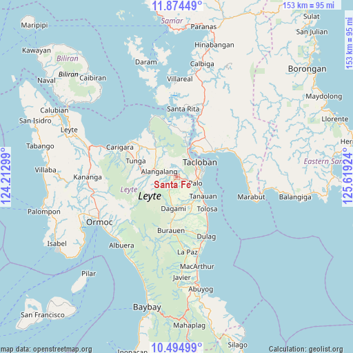
Santa Fe GPS coordinates[2]
11° 11' 8.016" North, 124° 54' 57.996" East
| Map corner | latitude | longitude |
|---|---|---|
| Upper-left | 11.87449°, | 124.21299° |
| Center: | 11.18556°, | 124.91611° |
| Lower-right: | 10.49499°, | 125.61924° |
| Map W x H: | 153.4×153.4 km | = 95.3×95.3mi |
| max Lat: | 20.78733° ⇑54.7% North |
| Santa Fe: | 11.18556° |
| min Lat: | ⇓45.3% South 4.65442° |
| min Long | Santa Fe | max Long |
| 117.04868° | 124.91611° | 126.58417° |
| W 86.5%⇐ | ⇒13.5% E |
Elevation
Elevation of Santa Fe is 22 m = 72 ft, and this is 65.9 m = 216 ft below average elevation for this country.
| Max E: |
2262 m = 7421 ft | 51.8% |
| Avg. | 87.9 m = 288 ft | |
| Santa Fe | 22 m = 72 ft | |
Min E: |
-2 m = -7 ft | 48.2% |
See also: Philippines elevation on elevation.city.
Geographical zone
Santa Fe is located in North Torrid zone (between Equator and Tropic of Cancer). Distance of Equator is 1243.7 km =772.8 mi to South.| Distance of | km | miles | from Santa Fe |
|---|---|---|---|
| North Pole | 8763.3 | 5445.3 | to North |
| Arctic Circle | 6157.5 | 3826.1 | to North |
| Tropic Cancer | 1362.2 | 846.4 | to North |
| Equator | 1243.7 | 772.8 | to South |


Nearby cities:
15 places around Santa Fe: (largest is in red/bold)
• Alangalang
7.9 km =4.9 mi,  286°
286°
• Baras
11 km =6.8 mi,  91°
91°
• Canhandugan
15.9 km =9.9 mi,  249°
249°
• Dagami
13.9 km =8.6 mi,  185°
185°
• Jaro
14.6 km =9.1 mi,  269°
269°
• Kabuynan
16.6 km =10.3 mi,  134°
134°
• Palo
8.7 km =5.4 mi,  110°
110°
• Panalanoy
12.3 km =7.6 mi,  53°
53°
• Pastrana
6.4 km =4 mi,  211°
211°
• Pawing
9.5 km =5.9 mi, 93°
• San Antonio
14.5 km =9 mi, 45°
• San Miguel
12.9 km =8 mi,  314°
314°
• Tacloban
11.6 km =7.2 mi,  56°
56°
• Tanauan
13.8 km =8.6 mi, 127°
• Tolosa
14.5 km =9 mi, 130°
Sources, notices
• [Note1] Compared only with cities in Philippines existing in our database
• [Src1] Map data: © OpenStreetMap contributors (CC-BY-SA)
• [Src2] Other city data from geonames.org with taken over terms of usage.
• [Src3] Geographical zone / Annual Mean Temperature by Robert A. Rohde @ Wikipedia
