Pines geodata
Pines (Northern Mindanao) is a populated place; located in Philippines in Asia/Manila (GMT+8) time zone. With population of 3,019 people, there are 2502 cities with bigger population in this country. Compared to other cities in Philippines, 79.1% of cities are located further ↑North; 68% of cities are located further ←West and 97.1% of cities have higher elevation than Pines. Note1
Administrative division(s):
- Level 1: Northern Mindanao
- Level 2: Province of Misamis Occidental
- Level 3: Oroquieta City


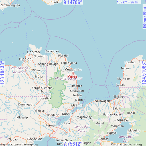
Pines GPS coordinates[2]
8° 27' 7.992" North, 123° 48' 27" East
| Map corner | latitude | longitude |
|---|---|---|
| Upper-left | 9.14706°, | 123.10438° |
| Center: | 8.45222°, | 123.8075° |
| Lower-right: | 7.75612°, | 124.51063° |
| Map W x H: | 154.7×154.7 km | = 96.1×96.1mi |
| max Lat: | 20.78733° ⇑79.1% North |
| Pines: | 8.45222° |
| min Lat: | ⇓20.9% South 4.65442° |
| min Long | Pines | max Long |
| 117.04868° | 123.8075° | 126.58417° |
| W 68%⇐ | ⇒32% E |
Elevation
Elevation of Pines is 4 m = 13 ft, and this is 83.9 m = 275 ft below average elevation for this country.
| Max E: |
2262 m = 7421 ft | 97.1% |
| Avg. | 87.9 m = 288 ft | |
| Pines | 4 m = 13 ft | |
Min E: |
-2 m = -7 ft | 2.9% |
See also: Philippines elevation on elevation.city.
Geographical zone
Pines is located in North Torrid zone (between Equator and Tropic of Cancer). Distance of Equator is 939.8 km =584 mi to South.| Distance of | km | miles | from Pines |
|---|---|---|---|
| North Pole | 9067.3 | 5634.2 | to North |
| Arctic Circle | 6461.4 | 4014.9 | to North |
| Tropic Cancer | 1666.1 | 1035.3 | to North |
| Equator | 939.8 | 584 | to South |


Nearby cities:
15 places around Pines: (largest is in red/bold)
• Bato
24.5 km =15.2 mi,  313°
313°
• Calamba
21.7 km =13.5 mi,  303°
303°
• Clarin
28.3 km =17.6 mi,  168°
168°
• Jimenez
13.3 km =8.3 mi, 165°
• Langcangan
6.4 km =4 mi, 298°
• Libertad
19.9 km =12.4 mi, 170°
• Lopez Jaena
12.3 km =7.6 mi,  335°
335°
• Oroquieta
3.8 km =2.4 mi,  355°
355°
• Pan-an
26.2 km =16.3 mi, 172°
• Plaridel
21.6 km =13.4 mi,  330°
330°
• Sinacaban
18.8 km =11.7 mi, 169°
• Sinonoc
16.4 km =10.2 mi, 165°
• Tubao
14.1 km =8.8 mi,  158°
158°
• Tudela
23.1 km =14.4 mi, 170°
• Unidos
22 km =13.7 mi,  315°
315°
Sources, notices
• [Note1] Compared only with cities in Philippines existing in our database
• [Src1] Map data: © OpenStreetMap contributors (CC-BY-SA)
• [Src2] Other city data from geonames.org with taken over terms of usage.
• [Src3] Geographical zone / Annual Mean Temperature by Robert A. Rohde @ Wikipedia
