Langcangan geodata
Langcangan (Northern Mindanao) is a populated place; located in Philippines in Asia/Manila (GMT+8) time zone. With population of 8,707 people, there are 710 cities with bigger population in this country. Compared to other cities in Philippines, 79% of cities are located further ↑North; 67% of cities are located further ←West and 84.5% of cities have lower elevation than Langcangan. Note1
Administrative division(s):
- Level 1: Northern Mindanao
- Level 2: Province of Misamis Occidental
- Level 3: Oroquieta City


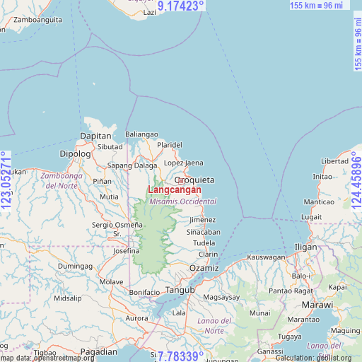
Langcangan GPS coordinates[2]
8° 28' 45.984" North, 123° 45' 20.988" East
| Map corner | latitude | longitude |
|---|---|---|
| Upper-left | 9.17423°, | 123.05271° |
| Center: | 8.47944°, | 123.75583° |
| Lower-right: | 7.78339°, | 124.45896° |
| Map W x H: | 154.6×154.7 km | = 96.1×96.1mi |
| max Lat: | 20.78733° ⇑79% North |
| Langcangan: | 8.47944° |
| min Lat: | ⇓21% South 4.65442° |
| min Long | Langcangan | max Long |
| 117.04868° | 123.75583° | 126.58417° |
| W 67%⇐ | ⇒33% E |
Elevation
Elevation of Langcangan is 130 m = 427 ft, and this is 42.1 m = 138 ft above average elevation for this country.
| Max E: |
2262 m = 7421 ft | 15.5% |
| Langcangan | 130 m 427 ft | |
| Avg. | 87.9 m = 288 ft | |
Min E: |
-2 m = -7 ft | 84.5% |
See also: Philippines elevation on elevation.city.
Geographical zone
Langcangan is located in North Torrid zone (between Equator and Tropic of Cancer). Distance of Equator is 942.8 km =585.8 mi to South.| Distance of | km | miles | from Langcangan |
|---|---|---|---|
| North Pole | 9064.2 | 5632.2 | to North |
| Arctic Circle | 6458.3 | 4013 | to North |
| Tropic Cancer | 1663.1 | 1033.4 | to North |
| Equator | 942.8 | 585.8 | to South |


Nearby cities:
15 places around Langcangan: (largest is in red/bold)
• Bato
18.3 km =11.4 mi,  318°
318°
• Calamba
15.3 km =9.5 mi,  305°
305°
• Jimenez
18.3 km =11.4 mi,  150°
150°
• Libertad
24.4 km =15.2 mi,  158°
158°
• Lopez Jaena
8.2 km =5.1 mi,  4°
4°
• Oroquieta
5.4 km =3.4 mi,  82°
82°
• Pan-an
30.4 km =18.9 mi, 162°
• Pines
6.4 km =4 mi,  118°
118°
• Plaridel
16.6 km =10.3 mi,  342°
342°
• Sapang Dalaga
22.3 km =13.9 mi,  287°
287°
• Sinacaban
23.4 km =14.5 mi, 156°
• Sinonoc
21.3 km =13.2 mi, 152°
• Tubao
19.5 km =12.1 mi, 146°
• Tudela
27.5 km =17.1 mi, 159°
• Unidos
16 km =9.9 mi, 322°
Sources, notices
• [Note1] Compared only with cities in Philippines existing in our database
• [Src1] Map data: © OpenStreetMap contributors (CC-BY-SA)
• [Src2] Other city data from geonames.org with taken over terms of usage.
• [Src3] Geographical zone / Annual Mean Temperature by Robert A. Rohde @ Wikipedia
