Oroquieta geodata
Oroquieta (Northern Mindanao) is a seat of a second-order administrative division; located in Philippines in Asia/Manila (GMT+8) time zone. With population of 39,279 people, there are 223 cities with bigger population in this country. Compared to other cities in Philippines, 78.8% of cities are located further ↑North; 68% of cities are located further ←West and 92.7% of cities have higher elevation than Oroquieta. Note1
Administrative division(s):
- Level 1: Northern Mindanao
- Level 2: Province of Misamis Occidental
- Level 3: Oroquieta City


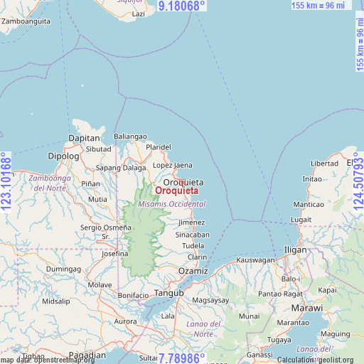
Oroquieta GPS coordinates[2]
8° 29' 9.24" North, 123° 48' 17.28" East
| Map corner | latitude | longitude |
|---|---|---|
| Upper-left | 9.18068°, | 123.10168° |
| Center: | 8.4859°, | 123.8048° |
| Lower-right: | 7.78986°, | 124.50793° |
| Map W x H: | 154.6×154.6 km | = 96.1×96.1mi |
| max Lat: | 20.78733° ⇑78.8% North |
| Oroquieta: | 8.4859° |
| min Lat: | ⇓21.2% South 4.65442° |
| min Long | Oroquieta | max Long |
| 117.04868° | 123.8048° | 126.58417° |
| W 68%⇐ | ⇒32% E |
Elevation
Elevation of Oroquieta is 6 m = 20 ft, and this is 81.9 m = 269 ft below average elevation for this country.
| Max E: |
2262 m = 7421 ft | 92.7% |
| Avg. | 87.9 m = 288 ft | |
| Oroquieta | 6 m = 20 ft | |
Min E: |
-2 m = -7 ft | 7.3% |
See also: Philippines elevation on elevation.city.
Geographical zone
Oroquieta is located in North Torrid zone (between Equator and Tropic of Cancer). Distance of Equator is 943.5 km =586.3 mi to South.| Distance of | km | miles | from Oroquieta |
|---|---|---|---|
| North Pole | 9063.5 | 5631.8 | to North |
| Arctic Circle | 6457.6 | 4012.6 | to North |
| Tropic Cancer | 1662.4 | 1033 | to North |
| Equator | 943.5 | 586.3 | to South |


Nearby cities:
15 places around Oroquieta: (largest is in red/bold)
• Bato
21.9 km =13.6 mi,  306°
306°
• Calamba
19.6 km =12.2 mi,  294°
294°
• Jimenez
17 km =10.6 mi,  167°
167°
• Langcangan
5.4 km =3.4 mi,  262°
262°
• Libertad
23.7 km =14.7 mi, 171°
• Lopez Jaena
8.8 km =5.5 mi,  327°
327°
• Pan-an
29.9 km =18.6 mi, 172°
• Pines
3.8 km =2.4 mi,  175°
175°
• Plaridel
18.3 km =11.4 mi, 325°
• Sapang Dalaga
27.3 km =17 mi,  282°
282°
• Sinacaban
22.5 km =14 mi, 170°
• Sinonoc
20.1 km =12.5 mi, 166°
• Tubao
17.8 km =11.1 mi,  161°
161°
• Tudela
26.9 km =16.7 mi, 171°
• Unidos
19.3 km =12 mi, 308°
Sources, notices
• [Note1] Compared only with cities in Philippines existing in our database
• [Src1] Map data: © OpenStreetMap contributors (CC-BY-SA)
• [Src2] Other city data from geonames.org with taken over terms of usage.
• [Src3] Geographical zone / Annual Mean Temperature by Robert A. Rohde @ Wikipedia
