Taal geodata
Taal (Calabarzon) is a seat of a third-order administrative division; located in Philippines in Asia/Manila (GMT+8) time zone. With population of 39,745 people, there are 216 cities with bigger population in this country. Compared to other cities in Philippines, 67.1% of cities are located further ↓South; 78.7% of cities are located further →East and 65.2% of cities have lower elevation than Taal. Note1


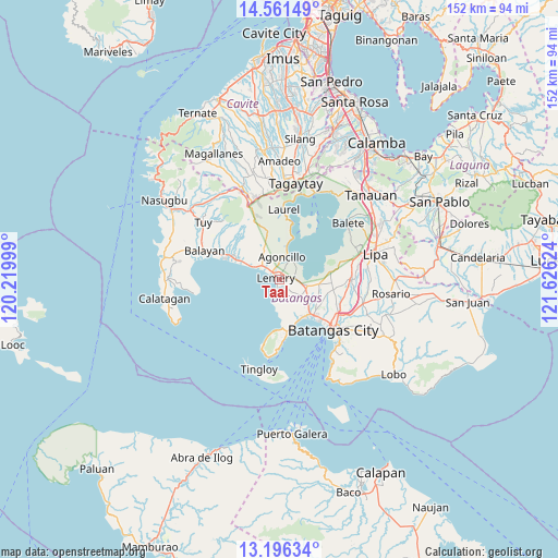
Taal GPS coordinates[2]
13° 52' 47.712" North, 120° 55' 23.196" East
| Map corner | latitude | longitude |
|---|---|---|
| Upper-left | 14.56149°, | 120.21999° |
| Center: | 13.87992°, | 120.92311° |
| Lower-right: | 13.19634°, | 121.62624° |
| Map W x H: | 151.8×151.8 km | = 94.3×94.3mi |
| max Lat: | 20.78733° ⇑32.9% North |
| Taal: | 13.87992° |
| min Lat: | ⇓67.1% South 4.65442° |
| min Long | Taal | max Long |
| 117.04868° | 120.92311° | 126.58417° |
| W 21.3%⇐ | ⇒78.7% E |
Elevation
Elevation of Taal is 42 m = 138 ft, and this is 45.9 m = 151 ft below average elevation for this country.
| Max E: |
2262 m = 7421 ft | 34.8% |
| Avg. | 87.9 m = 288 ft | |
| Taal | 42 m = 138 ft | |
Min E: |
-2 m = -7 ft | 65.2% |
See also: Philippines elevation on elevation.city.
Geographical zone
Taal is located in North Torrid zone (between Equator and Tropic of Cancer). Distance of this Northern Tropic circle is 1062.6 km =660.3 mi to North.| Distance of | km | miles | from Taal |
|---|---|---|---|
| North Pole | 8463.8 | 5259.2 | to North |
| Arctic Circle | 5857.9 | 3639.9 | to North |
| Tropic Cancer | 1062.6 | 660.3 | to North |
| Equator | 1543.3 | 959 | to South |


Nearby cities:
15 places around Taal: (largest is in red/bold)
• Agoncillo
6.3 km =3.9 mi,  9°
9°
• Alitagtag
8.9 km =5.5 mi,  101°
101°
• Calumpang
7 km =4.3 mi,  126°
126°
• Dayapan
6.4 km =4 mi,  353°
353°
• Inicbulan
9.3 km =5.8 mi,  135°
135°
• Lemery
1 km =0.6 mi,  276°
276°
• Matingain
5.9 km =3.7 mi,  308°
308°
• Mozon
7.8 km =4.8 mi,  113°
113°
• San Jose
4.2 km =2.6 mi, 137°
• San Luis
2.9 km =1.8 mi,  194°
194°
• San Nicolas
6.2 km =3.9 mi,  29°
29°
• Santa Teresita
6.5 km =4 mi, 103°
• Sinala
10 km =6.2 mi,  146°
146°
• Sinisian
9.4 km =5.8 mi,  294°
294°
• Subic
7.9 km =4.9 mi, 13°
Sources, notices
• [Note1] Compared only with cities in Philippines existing in our database
• [Src1] Map data: © OpenStreetMap contributors (CC-BY-SA)
• [Src2] Other city data from geonames.org with taken over terms of usage.
• [Src3] Geographical zone / Annual Mean Temperature by Robert A. Rohde @ Wikipedia
