Lemery geodata
Lemery (Calabarzon) is a seat of a third-order administrative division; located in Philippines in Asia/Manila (GMT+8) time zone. In our database, there are 4166 cities with bigger population. Compared to other cities in Philippines, 67.2% of cities are located further ↓South; 79% of cities are located further →East and 80.7% of cities have higher elevation than Lemery. Note1


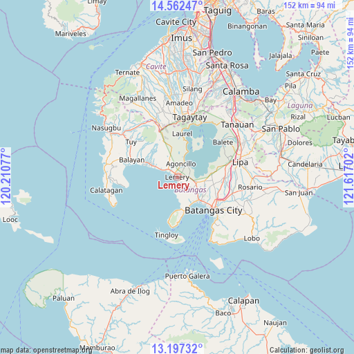
Lemery GPS coordinates[2]
13° 52' 51.24" North, 120° 54' 50.004" East
| Map corner | latitude | longitude |
|---|---|---|
| Upper-left | 14.56247°, | 120.21077° |
| Center: | 13.8809°, | 120.91389° |
| Lower-right: | 13.19732°, | 121.61702° |
| Map W x H: | 151.8×151.8 km | = 94.3×94.3mi |
| max Lat: | 20.78733° ⇑32.8% North |
| Lemery: | 13.8809° |
| min Lat: | ⇓67.2% South 4.65442° |
| min Long | Lemery | max Long |
| 117.04868° | 120.91389° | 126.58417° |
| W 21%⇐ | ⇒79% E |
Elevation
Elevation of Lemery is 9 m = 30 ft, and this is 78.9 m = 259 ft below average elevation for this country.
| Max E: |
2262 m = 7421 ft | 80.7% |
| Avg. | 87.9 m = 288 ft | |
| Lemery | 9 m = 30 ft | |
Min E: |
-2 m = -7 ft | 19.3% |
See also: Philippines elevation on elevation.city.
Geographical zone
Lemery is located in North Torrid zone (between Equator and Tropic of Cancer). Distance of this Northern Tropic circle is 1062.5 km =660.2 mi to North.| Distance of | km | miles | from Lemery |
|---|---|---|---|
| North Pole | 8463.7 | 5259.1 | to North |
| Arctic Circle | 5857.8 | 3639.9 | to North |
| Tropic Cancer | 1062.5 | 660.2 | to North |
| Equator | 1543.4 | 959 | to South |


Nearby cities:
15 places around Lemery: (largest is in red/bold)
• Agoncillo
6.4 km =4 mi,  18°
18°
• Alitagtag
9.9 km =6.2 mi,  100°
100°
• Calumpang
7.9 km =4.9 mi,  122°
122°
• Dayapan
6.3 km =3.9 mi,  2°
2°
• Inicbulan
10.1 km =6.3 mi,  131°
131°
• Matingain
5.1 km =3.2 mi,  314°
314°
• Mozon
8.7 km =5.4 mi,  111°
111°
• San Jose
5 km =3.1 mi, 129°
• San Luis
2.9 km =1.8 mi,  174°
174°
• San Nicolas
6.6 km =4.1 mi,  37°
37°
• Santa Teresita
7.5 km =4.7 mi, 102°
• Sinala
10.6 km =6.6 mi,  141°
141°
• Sinisian
8.5 km =5.3 mi,  297°
297°
• Subic
8 km =5 mi, 20°
• Taal
1 km =0.6 mi, 96°
Sources, notices
• [Note1] Compared only with cities in Philippines existing in our database
• [Src1] Map data: © OpenStreetMap contributors (CC-BY-SA)
• [Src2] Other city data from geonames.org with taken over terms of usage.
• [Src3] Geographical zone / Annual Mean Temperature by Robert A. Rohde @ Wikipedia
