Surallah geodata
Surallah (Soccsksargen) is a seat of a third-order administrative division; located in Philippines in Asia/Manila (GMT+8) time zone. With population of 31,089 people, there are 268 cities with bigger population in this country. Compared to other cities in Philippines, 96.4% of cities are located further ↑North; 83.1% of cities are located further ←West and 88.6% of cities have lower elevation than Surallah. Note1
Administrative division(s):
- Level 1: Soccsksargen
- Level 2: Province of South Cotabato
- Level 3: Surallah


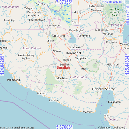
Surallah GPS coordinates[2]
6° 22' 30.972" North, 124° 44' 42.756" East
| Map corner | latitude | longitude |
|---|---|---|
| Upper-left | 7.07355°, | 124.04209° |
| Center: | 6.37527°, | 124.74521° |
| Lower-right: | 5.67603°, | 125.44834° |
| Map W x H: | 155.4×155.4 km | = 96.6×96.6mi |
| max Lat: | 20.78733° ⇑96.4% North |
| Surallah: | 6.37527° |
| min Lat: | ⇓3.6% South 4.65442° |
| min Long | Surallah | max Long |
| 117.04868° | 124.74521° | 126.58417° |
| W 83.1%⇐ | ⇒16.9% E |
Elevation
Elevation of Surallah is 195 m = 640 ft, and this is 107.1 m = 351 ft above average elevation for this country.
| Max E: |
2262 m = 7421 ft | 11.4% |
| Surallah | 195 m 640 ft | |
| Avg. | 87.9 m = 288 ft | |
Min E: |
-2 m = -7 ft | 88.6% |
See also: Philippines elevation on elevation.city.
Geographical zone
Surallah is located in North Torrid zone (between Equator and Tropic of Cancer). Distance of Equator is 708.9 km =440.5 mi to South.| Distance of | km | miles | from Surallah |
|---|---|---|---|
| North Pole | 9298.2 | 5777.6 | to North |
| Arctic Circle | 6692.3 | 4158.4 | to North |
| Tropic Cancer | 1897.1 | 1178.8 | to North |
| Equator | 708.9 | 440.5 | to South |


Nearby cities:
15 places around Surallah: (largest is in red/bold)
• Bañga
6.5 km =4 mi,  34°
34°
• Colongulo
4.8 km =3 mi,  212°
212°
• Dahay
3.8 km =2.4 mi,  296°
296°
• Esperanza
16.1 km =10 mi,  327°
327°
• Guinsang-an
12 km =7.5 mi, 326°
• Lamba
8.7 km =5.4 mi,  108°
108°
• Lambontong
10.4 km =6.5 mi,  135°
135°
• Lamian
13.4 km =8.3 mi,  123°
123°
• Lopez Jaena
12.3 km =7.6 mi,  335°
335°
• Manuel Roxas
11.5 km =7.1 mi,  310°
310°
• Paraiso
13.3 km =8.3 mi, 32°
• San Miguel
14.1 km =8.8 mi, 337°
• San Vicente
9.5 km =5.9 mi,  23°
23°
• Santo Niño
8.5 km =5.3 mi,  321°
321°
• Teresita
6 km =3.7 mi, 316°
Sources, notices
• [Note1] Compared only with cities in Philippines existing in our database
• [Src1] Map data: © OpenStreetMap contributors (CC-BY-SA)
• [Src2] Other city data from geonames.org with taken over terms of usage.
• [Src3] Geographical zone / Annual Mean Temperature by Robert A. Rohde @ Wikipedia
