San Vicente geodata
San Vicente (Soccsksargen) is a populated place; located in Philippines in Asia/Manila (GMT+8) time zone. With population of 3,247 people, there are 2259 cities with bigger population in this country. Compared to other cities in Philippines, 96% of cities are located further ↑North; 83.7% of cities are located further ←West and 86.3% of cities have lower elevation than San Vicente. Note1
Administrative division(s):
- Level 1: Soccsksargen
- Level 2: Province of South Cotabato
- Level 3: Banga


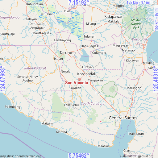
San Vicente GPS coordinates[2]
6° 27' 13.5" North, 124° 46' 48.18" East
| Map corner | latitude | longitude |
|---|---|---|
| Upper-left | 7.15192°, | 124.07693° |
| Center: | 6.45375°, | 124.78005° |
| Lower-right: | 5.75462°, | 125.48318° |
| Map W x H: | 155.4×155.4 km | = 96.6×96.6mi |
| max Lat: | 20.78733° ⇑96% North |
| San Vicente: | 6.45375° |
| min Lat: | ⇓4% South 4.65442° |
| min Long | San Vicente | max Long |
| 117.04868° | 124.78005° | 126.58417° |
| W 83.7%⇐ | ⇒16.3% E |
Elevation
Elevation of San Vicente is 155 m = 509 ft, and this is 67.1 m = 220 ft above average elevation for this country.
| Max E: |
2262 m = 7421 ft | 13.7% |
| San Vicente | 155 m 509 ft | |
| Avg. | 87.9 m = 288 ft | |
Min E: |
-2 m = -7 ft | 86.3% |
See also: Philippines elevation on elevation.city.
Geographical zone
San Vicente is located in North Torrid zone (between Equator and Tropic of Cancer). Distance of Equator is 717.6 km =445.9 mi to South.| Distance of | km | miles | from San Vicente |
|---|---|---|---|
| North Pole | 9289.5 | 5772.2 | to North |
| Arctic Circle | 6683.6 | 4153 | to North |
| Tropic Cancer | 1888.3 | 1173.3 | to North |
| Equator | 717.6 | 445.9 | to South |


Nearby cities:
15 places around San Vicente: (largest is in red/bold)
• Bañga
3.3 km =2.1 mi,  183°
183°
• Bukay Pait
12.1 km =7.5 mi,  353°
353°
• Carpenter Hill
11.2 km =7 mi,  95°
95°
• Dahay
10.1 km =6.3 mi,  225°
225°
• Guinsang-an
10.6 km =6.6 mi,  276°
276°
• Koronadal
9.2 km =5.7 mi,  53°
53°
• Lamba
12.3 km =7.6 mi,  159°
159°
• Libas
7.4 km =4.6 mi,  1°
1°
• Lopez Jaena
9.4 km =5.8 mi,  285°
285°
• New Iloilo
10.5 km =6.5 mi,  5°
5°
• Paraiso
4.1 km =2.5 mi, 52°
• San Miguel
10.2 km =6.3 mi, 294°
• Santo Niño
9.4 km =5.8 mi,  257°
257°
• Surallah
9.5 km =5.9 mi,  203°
203°
• Teresita
9.1 km =5.7 mi,  241°
241°
Sources, notices
• [Note1] Compared only with cities in Philippines existing in our database
• [Src1] Map data: © OpenStreetMap contributors (CC-BY-SA)
• [Src2] Other city data from geonames.org with taken over terms of usage.
• [Src3] Geographical zone / Annual Mean Temperature by Robert A. Rohde @ Wikipedia
