Sogod geodata
Sogod (Bicol) is a populated place; located in Philippines in Asia/Manila (GMT+8) time zone. With population of 2,960 people, there are 2578 cities with bigger population in this country. Compared to other cities in Philippines, 66% of cities are located further ↓South; 58.6% of cities are located further ←West and 99.6% of cities have higher elevation than Sogod. Note1


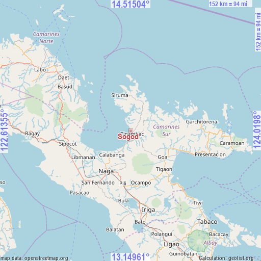
Sogod GPS coordinates[2]
13° 49' 59.988" North, 123° 19' 0.012" East
| Map corner | latitude | longitude |
|---|---|---|
| Upper-left | 14.51504°, | 122.61355° |
| Center: | 13.83333°, | 123.31667° |
| Lower-right: | 13.14961°, | 124.0198° |
| Map W x H: | 151.8×151.8 km | = 94.3×94.3mi |
| max Lat: | 20.78733° ⇑34% North |
| Sogod: | 13.83333° |
| min Lat: | ⇓66% South 4.65442° |
| min Long | Sogod | max Long |
| 117.04868° | 123.31667° | 126.58417° |
| W 58.6%⇐ | ⇒41.4% E |
Elevation
Elevation of Sogod is 1 m = 3 ft, and this is 86.9 m = 285 ft below average elevation for this country.
| Max E: |
2262 m = 7421 ft | 99.6% |
| Avg. | 87.9 m = 288 ft | |
| Sogod | 1 m = 3 ft | |
Min E: |
-2 m = -7 ft | 0.4% |
See also: Philippines elevation on elevation.city.
Geographical zone
Sogod is located in North Torrid zone (between Equator and Tropic of Cancer). Distance of this Northern Tropic circle is 1067.8 km =663.5 mi to North.| Distance of | km | miles | from Sogod |
|---|---|---|---|
| North Pole | 8468.9 | 5262.3 | to North |
| Arctic Circle | 5863.1 | 3643.2 | to North |
| Tropic Cancer | 1067.8 | 663.5 | to North |
| Equator | 1538.1 | 955.7 | to South |


Nearby cities:
15 places around Sogod: (largest is in red/bold)
• Bagacay
6.4 km =4 mi,  193°
193°
• Binanwanaan
14.9 km =9.3 mi, 186°
• Bombon
19.9 km =12.4 mi,  216°
216°
• Buenavista
4.1 km =2.5 mi,  337°
337°
• Calabanga
18.3 km =11.4 mi, 219°
• Kaliliog
8.3 km =5.2 mi, 341°
• Magarao
23.8 km =14.8 mi, 216°
• Manquiring
12.2 km =7.6 mi,  205°
205°
• Paulba
15.2 km =9.4 mi, 208°
• Pili
18.5 km =11.5 mi,  180°
180°
• San Lucas
18.7 km =11.6 mi, 220°
• San Vicente
19.5 km =12.1 mi, 220°
• Santo Domingo
22 km =13.7 mi,  227°
227°
• Siruma
19.9 km =12.4 mi, 338°
• Tinambac
2.1 km =1.3 mi,  151°
151°
Sources, notices
• [Note1] Compared only with cities in Philippines existing in our database
• [Src1] Map data: © OpenStreetMap contributors (CC-BY-SA)
• [Src2] Other city data from geonames.org with taken over terms of usage.
• [Src3] Geographical zone / Annual Mean Temperature by Robert A. Rohde @ Wikipedia
