Buenavista geodata
Buenavista (Bicol) is a populated place; located in Philippines in Asia/Manila (GMT+8) time zone. With population of 2,197 people, there are 3894 cities with bigger population in this country. Compared to other cities in Philippines, 66.8% of cities are located further ↓South; 58.4% of cities are located further ←West and 54.5% of cities have higher elevation than Buenavista. Note1


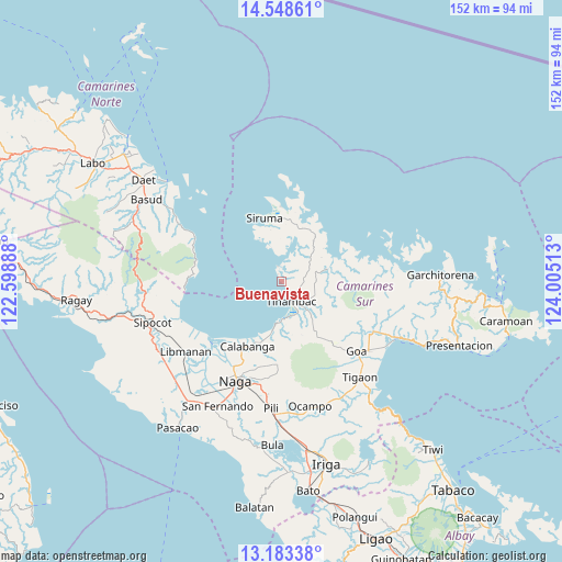
Buenavista GPS coordinates[2]
13° 52' 1.2" North, 123° 18' 7.2" East
| Map corner | latitude | longitude |
|---|---|---|
| Upper-left | 14.54861°, | 122.59888° |
| Center: | 13.867°, | 123.302° |
| Lower-right: | 13.18338°, | 124.00513° |
| Map W x H: | 151.8×151.8 km | = 94.3×94.3mi |
| max Lat: | 20.78733° ⇑33.2% North |
| Buenavista: | 13.867° |
| min Lat: | ⇓66.8% South 4.65442° |
| min Long | Buenavista | max Long |
| 117.04868° | 123.302° | 126.58417° |
| W 58.4%⇐ | ⇒41.6% E |
Elevation
Elevation of Buenavista is 20 m = 66 ft, and this is 67.9 m = 223 ft below average elevation for this country.
| Max E: |
2262 m = 7421 ft | 54.5% |
| Avg. | 87.9 m = 288 ft | |
| Buenavista | 20 m = 66 ft | |
Min E: |
-2 m = -7 ft | 45.5% |
See also: Philippines elevation on elevation.city.
Geographical zone
Buenavista is located in North Torrid zone (between Equator and Tropic of Cancer). Distance of this Northern Tropic circle is 1064.1 km =661.2 mi to North.| Distance of | km | miles | from Buenavista |
|---|---|---|---|
| North Pole | 8465.2 | 5260 | to North |
| Arctic Circle | 5859.3 | 3640.8 | to North |
| Tropic Cancer | 1064.1 | 661.2 | to North |
| Equator | 1541.9 | 958.1 | to South |


Nearby cities:
15 places around Buenavista: (largest is in red/bold)
• Bagacay
10 km =6.2 mi,  179°
179°
• Binanwanaan
18.6 km =11.6 mi, 180°
• Bombon
22.3 km =13.9 mi,  207°
207°
• Calabanga
20.5 km =12.7 mi, 209°
• Castillo
25.1 km =15.6 mi,  232°
232°
• Kaliliog
4.2 km =2.6 mi,  345°
345°
• Manquiring
15.2 km =9.4 mi,  193°
193°
• Paulba
18 km =11.2 mi,  198°
198°
• Pili
22.3 km =13.9 mi, 175°
• San Lucas
20.8 km =12.9 mi, 210°
• San Vicente
21.6 km =13.4 mi, 210°
• Santo Domingo
23.6 km =14.7 mi,  218°
218°
• Siruma
15.8 km =9.8 mi,  339°
339°
• Sogod
4.1 km =2.5 mi,  157°
157°
• Tinambac
6.2 km =3.9 mi, 155°
Sources, notices
• [Note1] Compared only with cities in Philippines existing in our database
• [Src1] Map data: © OpenStreetMap contributors (CC-BY-SA)
• [Src2] Other city data from geonames.org with taken over terms of usage.
• [Src3] Geographical zone / Annual Mean Temperature by Robert A. Rohde @ Wikipedia
