Bagacay geodata
Bagacay (Bicol) is a populated place; located in Philippines in Asia/Manila (GMT+8) time zone. With population of 2,991 people, there are 2534 cities with bigger population in this country. Compared to other cities in Philippines, 65.2% of cities are located further ↓South; 58.4% of cities are located further ←West and 92.7% of cities have higher elevation than Bagacay. Note1


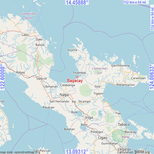
Bagacay GPS coordinates[2]
13° 46' 37.2" North, 123° 18' 11.52" East
| Map corner | latitude | longitude |
|---|---|---|
| Upper-left | 14.45888°, | 122.60008° |
| Center: | 13.777°, | 123.3032° |
| Lower-right: | 13.09312°, | 124.00633° |
| Map W x H: | 151.9×151.9 km | = 94.4×94.4mi |
| max Lat: | 20.78733° ⇑34.8% North |
| Bagacay: | 13.777° |
| min Lat: | ⇓65.2% South 4.65442° |
| min Long | Bagacay | max Long |
| 117.04868° | 123.3032° | 126.58417° |
| W 58.4%⇐ | ⇒41.6% E |
Elevation
Elevation of Bagacay is 6 m = 20 ft, and this is 81.9 m = 269 ft below average elevation for this country.
| Max E: |
2262 m = 7421 ft | 92.7% |
| Avg. | 87.9 m = 288 ft | |
| Bagacay | 6 m = 20 ft | |
Min E: |
-2 m = -7 ft | 7.3% |
See also: Philippines elevation on elevation.city.
Geographical zone
Bagacay is located in North Torrid zone (between Equator and Tropic of Cancer). Distance of this Northern Tropic circle is 1074.1 km =667.4 mi to North.| Distance of | km | miles | from Bagacay |
|---|---|---|---|
| North Pole | 8475.2 | 5266.2 | to North |
| Arctic Circle | 5869.3 | 3647 | to North |
| Tropic Cancer | 1074.1 | 667.4 | to North |
| Equator | 1531.9 | 951.9 | to South |


Nearby cities:
15 places around Bagacay: (largest is in red/bold)
• Binanwanaan
8.6 km =5.3 mi,  182°
182°
• Bombon
14.2 km =8.8 mi,  226°
226°
• Buenavista
10 km =6.2 mi,  359°
359°
• Calabanga
12.8 km =8 mi, 232°
• Kaliliog
14.2 km =8.8 mi, 355°
• Magarao
18.1 km =11.2 mi,  224°
224°
• Manquiring
6 km =3.7 mi, 217°
• Palestina
19.3 km =12 mi,  197°
197°
• Paulba
9.1 km =5.7 mi, 219°
• Pili
12.4 km =7.7 mi,  173°
173°
• San Lucas
13.4 km =8.3 mi, 233°
• San Vicente
14.1 km =8.8 mi, 232°
• Santo Domingo
17.1 km =10.6 mi,  239°
239°
• Sogod
6.4 km =4 mi,  13°
13°
• Tinambac
5 km =3.1 mi,  29°
29°
Sources, notices
• [Note1] Compared only with cities in Philippines existing in our database
• [Src1] Map data: © OpenStreetMap contributors (CC-BY-SA)
• [Src2] Other city data from geonames.org with taken over terms of usage.
• [Src3] Geographical zone / Annual Mean Temperature by Robert A. Rohde @ Wikipedia
