Sison geodata
Sison (Ilocos) is a seat of a third-order administrative division; located in Philippines in Asia/Manila (GMT+8) time zone. With population of 9,256 people, there are 666 cities with bigger population in this country. Compared to other cities in Philippines, 89.3% of cities are located further ↓South; 90.6% of cities are located further →East and 80.1% of cities have lower elevation than Sison. Note1


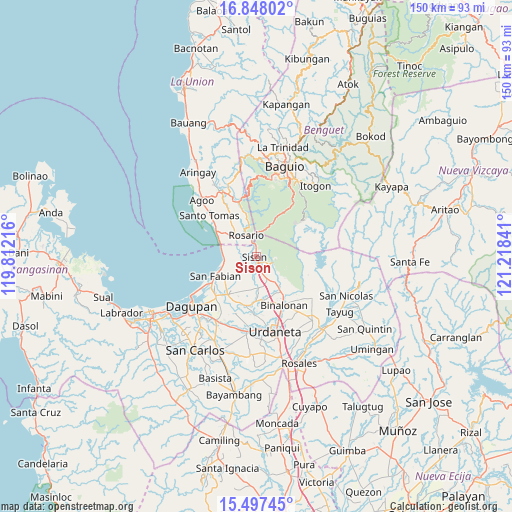
Sison GPS coordinates[2]
16° 10' 26.004" North, 120° 30' 55.008" East
| Map corner | latitude | longitude |
|---|---|---|
| Upper-left | 16.84802°, | 119.81216° |
| Center: | 16.17389°, | 120.51528° |
| Lower-right: | 15.49745°, | 121.21841° |
| Map W x H: | 150.2×150.2 km | = 93.3×93.3mi |
| max Lat: | 20.78733° ⇑10.7% North |
| Sison: | 16.17389° |
| min Lat: | ⇓89.3% South 4.65442° |
| min Long | Sison | max Long |
| 117.04868° | 120.51528° | 126.58417° |
| W 9.4%⇐ | ⇒90.6% E |
Elevation
Elevation of Sison is 93 m = 305 ft, and this is 5.1 m = 17 ft above average elevation for this country.
| Max E: |
2262 m = 7421 ft | 19.9% |
| Sison | 93 m 305 ft | |
| Avg. | 87.9 m = 288 ft | |
Min E: |
-2 m = -7 ft | 80.1% |
See also: Philippines elevation on elevation.city.
Geographical zone
Sison is located in North Torrid zone (between Equator and Tropic of Cancer). Distance of this Northern Tropic circle is 807.6 km =501.8 mi to North.| Distance of | km | miles | from Sison |
|---|---|---|---|
| North Pole | 8208.7 | 5100.6 | to North |
| Arctic Circle | 5602.8 | 3481.4 | to North |
| Tropic Cancer | 807.6 | 501.8 | to North |
| Equator | 1798.4 | 1117.5 | to South |


Nearby cities:
15 places around Sison: (largest is in red/bold)
• Amagbagan
9.2 km =5.7 mi,  174°
174°
• Bataquil
2.4 km =1.5 mi,  147°
147°
• Binday
8.4 km =5.2 mi,  232°
232°
• Bobonan
4.5 km =2.8 mi,  163°
163°
• Dilan
9.6 km =6 mi,  176°
176°
• Labayug
5.9 km =3.7 mi,  113°
113°
• Labney
9.5 km =5.9 mi,  213°
213°
• Nama
4.7 km =2.9 mi,  141°
141°
• Palacpalac
5 km =3.1 mi, 161°
• Paldit
2.1 km =1.3 mi, 112°
• Palguyod
5.7 km =3.5 mi, 174°
• Pozorrubio
7.6 km =4.7 mi, 156°
• Rosario
7 km =4.3 mi,  333°
333°
• Sagunto
3 km =1.9 mi,  359°
359°
• Subusub
6.3 km =3.9 mi,  339°
339°
Sources, notices
• [Note1] Compared only with cities in Philippines existing in our database
• [Src1] Map data: © OpenStreetMap contributors (CC-BY-SA)
• [Src2] Other city data from geonames.org with taken over terms of usage.
• [Src3] Geographical zone / Annual Mean Temperature by Robert A. Rohde @ Wikipedia
