Sagunto geodata
Sagunto (Ilocos) is a populated place; located in Philippines in Asia/Manila (GMT+8) time zone. With population of 2,082 people, there are 4098 cities with bigger population in this country. Compared to other cities in Philippines, 89.4% of cities are located further ↓South; 90.6% of cities are located further →East and 85.8% of cities have lower elevation than Sagunto. Note1


Sagunto GPS coordinates[2]
16° 12' 2.52" North, 120° 30' 53.64" East
| Map corner | latitude | longitude |
|---|---|---|
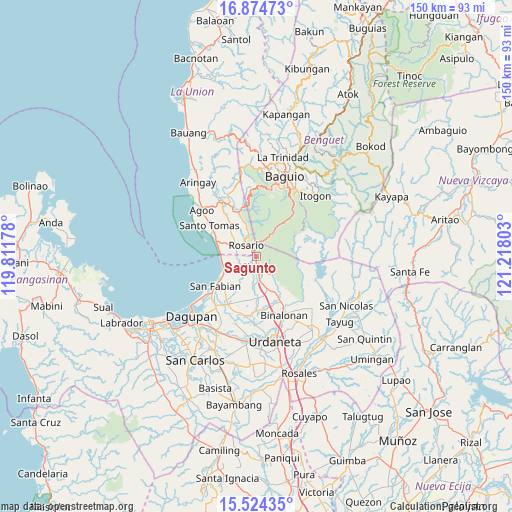
| Upper-left | 16.87473°, | 119.81178° |
| Center: | 16.2007°, | 120.5149° |
| Lower-right: | 15.52435°, | 121.21803° |
| Map W x H: | 150.1×150.2 km | = 93.3×93.3mi |
| max Lat: | 20.78733° ⇑10.6% North |
| Sagunto: | 16.2007° |
| min Lat: | ⇓89.4% South 4.65442° |
| min Long | Sagunto | max Long |
| 117.04868° | 120.5149° | 126.58417° |
| W 9.4%⇐ | ⇒90.6% E |
Elevation
Elevation of Sagunto is 149 m = 489 ft, and this is 61.1 m = 200 ft above average elevation for this country.
| Max E: |
2262 m = 7421 ft | 14.2% |
| Sagunto | 149 m 489 ft | |
| Avg. | 87.9 m = 288 ft | |
Min E: |
-2 m = -7 ft | 85.8% |
See also: Philippines elevation on elevation.city.
Geographical zone
Sagunto is located in North Torrid zone (between Equator and Tropic of Cancer). Distance of this Northern Tropic circle is 804.6 km =500 mi to North.| Distance of | km | miles | from Sagunto |
|---|---|---|---|
| North Pole | 8205.7 | 5098.8 | to North |
| Arctic Circle | 5599.8 | 3479.6 | to North |
| Tropic Cancer | 804.6 | 500 | to North |
| Equator | 1801.3 | 1119.3 | to South |


Nearby cities:
15 places around Sagunto: (largest is in red/bold)
• Bataquil
5.2 km =3.2 mi,  165°
165°
• Binday
10.5 km =6.5 mi,  219°
219°
• Bobonan
7.4 km =4.6 mi, 169°
• Caronoan West
10.1 km =6.3 mi,  313°
313°
• Inabaan Sur
8 km =5 mi,  330°
330°
• Labayug
7.6 km =4.7 mi,  134°
134°
• Mabilao
10.9 km =6.8 mi,  241°
241°
• Nama
7.2 km =4.5 mi,  155°
155°
• Palacpalac
7.9 km =4.9 mi, 167°
• Paldit
4.3 km =2.7 mi,  152°
152°
• Palguyod
8.7 km =5.4 mi,  176°
176°
• Pozorrubio
10.4 km =6.5 mi, 162°
• Rosario
4.5 km =2.8 mi,  317°
317°
• Sison
3 km =1.9 mi, 179°
• Subusub
3.6 km =2.2 mi, 324°
Sources, notices
• [Note1] Compared only with cities in Philippines existing in our database
• [Src1] Map data: © OpenStreetMap contributors (CC-BY-SA)
• [Src2] Other city data from geonames.org with taken over terms of usage.
• [Src3] Geographical zone / Annual Mean Temperature by Robert A. Rohde @ Wikipedia
