Bataquil geodata
Bataquil (Ilocos) is a populated place; located in Philippines in Asia/Manila (GMT+8) time zone. With population of 2,504 people, there are 3275 cities with bigger population in this country. Compared to other cities in Philippines, 89.1% of cities are located further ↓South; 90.1% of cities are located further →East and 74.9% of cities have lower elevation than Bataquil. Note1


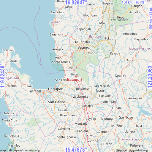
Bataquil GPS coordinates[2]
16° 9' 19.008" North, 120° 31' 39" East
| Map corner | latitude | longitude |
|---|---|---|
| Upper-left | 16.82947°, | 119.82438° |
| Center: | 16.15528°, | 120.5275° |
| Lower-right: | 15.47878°, | 121.23063° |
| Map W x H: | 150.2×150.2 km | = 93.3×93.3mi |
| max Lat: | 20.78733° ⇑10.9% North |
| Bataquil: | 16.15528° |
| min Lat: | ⇓89.1% South 4.65442° |
| min Long | Bataquil | max Long |
| 117.04868° | 120.5275° | 126.58417° |
| W 9.9%⇐ | ⇒90.1% E |
Elevation
Elevation of Bataquil is 68 m = 223 ft, and this is 19.9 m = 65 ft below average elevation for this country.
| Max E: |
2262 m = 7421 ft | 25.1% |
| Avg. | 87.9 m = 288 ft | |
| Bataquil | 68 m = 223 ft | |
Min E: |
-2 m = -7 ft | 74.9% |
See also: Philippines elevation on elevation.city.
Geographical zone
Bataquil is located in North Torrid zone (between Equator and Tropic of Cancer). Distance of this Northern Tropic circle is 809.6 km =503.1 mi to North.| Distance of | km | miles | from Bataquil |
|---|---|---|---|
| North Pole | 8210.8 | 5102 | to North |
| Arctic Circle | 5604.9 | 3482.7 | to North |
| Tropic Cancer | 809.6 | 503.1 | to North |
| Equator | 1796.3 | 1116.2 | to South |


Nearby cities:
15 places around Bataquil: (largest is in red/bold)
• Amagbagan
7.1 km =4.4 mi,  183°
183°
• Binday
8.6 km =5.3 mi,  249°
249°
• Bobonan
2.3 km =1.4 mi, 181°
• Dilan
7.5 km =4.7 mi,  185°
185°
• Labayug
4.1 km =2.5 mi,  93°
93°
• Labney
8.8 km =5.5 mi,  228°
228°
• Nama
2.2 km =1.4 mi,  134°
134°
• Palacpalac
2.7 km =1.7 mi,  173°
173°
• Paldit
1.4 km =0.9 mi,  26°
26°
• Palguyod
3.7 km =2.3 mi, 192°
• Pozorrubio
5.2 km =3.2 mi,  160°
160°
• Rosario
9.4 km =5.8 mi,  332°
332°
• Sagunto
5.2 km =3.2 mi,  345°
345°
• Sison
2.4 km =1.5 mi, 327°
• Subusub
8.7 km =5.4 mi,  336°
336°
Sources, notices
• [Note1] Compared only with cities in Philippines existing in our database
• [Src1] Map data: © OpenStreetMap contributors (CC-BY-SA)
• [Src2] Other city data from geonames.org with taken over terms of usage.
• [Src3] Geographical zone / Annual Mean Temperature by Robert A. Rohde @ Wikipedia
