Nama geodata
Nama (Ilocos) is a populated place; located in Philippines in Asia/Manila (GMT+8) time zone. With population of 2,355 people, there are 3549 cities with bigger population in this country. Compared to other cities in Philippines, 89% of cities are located further ↓South; 89.8% of cities are located further →East and 74.6% of cities have lower elevation than Nama. Note1


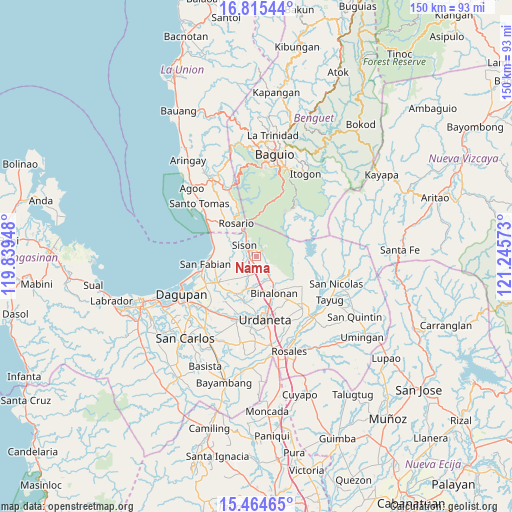
Nama GPS coordinates[2]
16° 8' 28.32" North, 120° 32' 33.36" East
| Map corner | latitude | longitude |
|---|---|---|
| Upper-left | 16.81544°, | 119.83948° |
| Center: | 16.1412°, | 120.5426° |
| Lower-right: | 15.46465°, | 121.24573° |
| Map W x H: | 150.2×150.2 km | = 93.3×93.3mi |
| max Lat: | 20.78733° ⇑11% North |
| Nama: | 16.1412° |
| min Lat: | ⇓89% South 4.65442° |
| min Long | Nama | max Long |
| 117.04868° | 120.5426° | 126.58417° |
| W 10.2%⇐ | ⇒89.8% E |
Elevation
Elevation of Nama is 67 m = 220 ft, and this is 20.9 m = 69 ft below average elevation for this country.
| Max E: |
2262 m = 7421 ft | 25.4% |
| Avg. | 87.9 m = 288 ft | |
| Nama | 67 m = 220 ft | |
Min E: |
-2 m = -7 ft | 74.6% |
See also: Philippines elevation on elevation.city.
Geographical zone
Nama is located in North Torrid zone (between Equator and Tropic of Cancer). Distance of this Northern Tropic circle is 811.2 km =504.1 mi to North.| Distance of | km | miles | from Nama |
|---|---|---|---|
| North Pole | 8212.3 | 5102.9 | to North |
| Arctic Circle | 5606.4 | 3483.7 | to North |
| Tropic Cancer | 811.2 | 504.1 | to North |
| Equator | 1794.7 | 1115.2 | to South |


Nearby cities:
15 places around Nama: (largest is in red/bold)
• Amagbagan
5.9 km =3.7 mi,  200°
200°
• Bataquil
2.2 km =1.4 mi,  314°
314°
• Binday
9.7 km =6 mi,  261°
261°
• Bobonan
1.8 km =1.1 mi,  246°
246°
• Dilan
6.4 km =4 mi, 201°
• Labayug
2.8 km =1.7 mi,  62°
62°
• Labney
9.3 km =5.8 mi,  242°
242°
• Lobong
10.2 km =6.3 mi,  229°
229°
• Palacpalac
1.7 km =1.1 mi, 229°
• Paldit
3 km =1.9 mi,  340°
340°
• Palguyod
3.2 km =2 mi, 229°
• Pozorrubio
3.4 km =2.1 mi,  177°
177°
• Sagunto
7.2 km =4.5 mi, 335°
• Sison
4.7 km =2.9 mi,  321°
321°
• Subusub
10.8 km =6.7 mi,  331°
331°
Sources, notices
• [Note1] Compared only with cities in Philippines existing in our database
• [Src1] Map data: © OpenStreetMap contributors (CC-BY-SA)
• [Src2] Other city data from geonames.org with taken over terms of usage.
• [Src3] Geographical zone / Annual Mean Temperature by Robert A. Rohde @ Wikipedia
