Paldit geodata
Paldit (Ilocos) is a populated place; located in Philippines in Asia/Manila (GMT+8) time zone. With population of 3,664 people, there are 1938 cities with bigger population in this country. Compared to other cities in Philippines, 89.2% of cities are located further ↓South; 90% of cities are located further →East and 80.6% of cities have lower elevation than Paldit. Note1


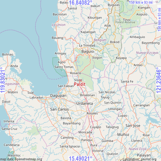
Paldit GPS coordinates[2]
16° 10' 0.012" North, 120° 31' 59.988" East
| Map corner | latitude | longitude |
|---|---|---|
| Upper-left | 16.84082°, | 119.83021° |
| Center: | 16.16667°, | 120.53333° |
| Lower-right: | 15.49021°, | 121.23646° |
| Map W x H: | 150.2×150.2 km | = 93.3×93.3mi |
| max Lat: | 20.78733° ⇑10.8% North |
| Paldit: | 16.16667° |
| min Lat: | ⇓89.2% South 4.65442° |
| min Long | Paldit | max Long |
| 117.04868° | 120.53333° | 126.58417° |
| W 10%⇐ | ⇒90% E |
Elevation
Elevation of Paldit is 95 m = 312 ft, and this is 7.1 m = 23 ft above average elevation for this country.
| Max E: |
2262 m = 7421 ft | 19.4% |
| Paldit | 95 m 312 ft | |
| Avg. | 87.9 m = 288 ft | |
Min E: |
-2 m = -7 ft | 80.6% |
See also: Philippines elevation on elevation.city.
Geographical zone
Paldit is located in North Torrid zone (between Equator and Tropic of Cancer). Distance of this Northern Tropic circle is 808.4 km =502.3 mi to North.| Distance of | km | miles | from Paldit |
|---|---|---|---|
| North Pole | 8209.5 | 5101.1 | to North |
| Arctic Circle | 5603.6 | 3481.9 | to North |
| Tropic Cancer | 808.4 | 502.3 | to North |
| Equator | 1797.6 | 1117 | to South |


Nearby cities:
15 places around Paldit: (largest is in red/bold)
• Amagbagan
8.4 km =5.2 mi,  187°
187°
• Bataquil
1.4 km =0.9 mi,  206°
206°
• Binday
9.6 km =6 mi,  243°
243°
• Bobonan
3.6 km =2.2 mi, 190°
• Dilan
8.9 km =5.5 mi, 188°
• Labayug
3.8 km =2.4 mi,  113°
113°
• Labney
10.1 km =6.3 mi,  225°
225°
• Nama
3 km =1.9 mi,  160°
160°
• Palacpalac
4 km =2.5 mi,  184°
184°
• Palguyod
5.1 km =3.2 mi,  196°
196°
• Pozorrubio
6.3 km =3.9 mi,  169°
169°
• Rosario
8.7 km =5.4 mi,  324°
324°
• Sagunto
4.3 km =2.7 mi,  332°
332°
• Sison
2.1 km =1.3 mi,  292°
292°
• Subusub
7.8 km =4.8 mi, 328°
Sources, notices
• [Note1] Compared only with cities in Philippines existing in our database
• [Src1] Map data: © OpenStreetMap contributors (CC-BY-SA)
• [Src2] Other city data from geonames.org with taken over terms of usage.
• [Src3] Geographical zone / Annual Mean Temperature by Robert A. Rohde @ Wikipedia
