Balinsacayao geodata
Balinsacayao (Eastern Visayas) is a populated place; located in Philippines in Asia/Manila (GMT+8) time zone. With population of 2,404 people, there are 3452 cities with bigger population in this country. Compared to other cities in Philippines, 61.2% of cities are located further ↑North; 86.9% of cities are located further ←West and 60.3% of cities have lower elevation than Balinsacayao. Note1


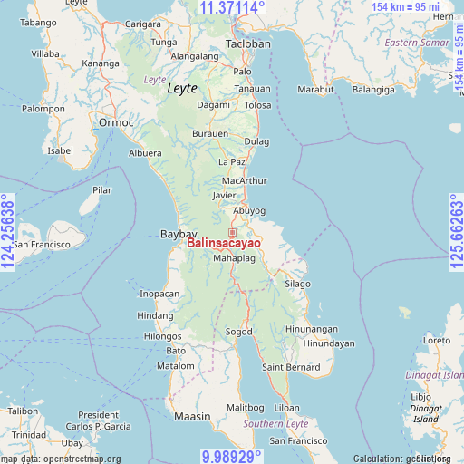
Balinsacayao GPS coordinates[2]
10° 40' 51.6" North, 124° 57' 34.2" East
| Map corner | latitude | longitude |
|---|---|---|
| Upper-left | 11.37114°, | 124.25638° |
| Center: | 10.681°, | 124.9595° |
| Lower-right: | 9.98929°, | 125.66263° |
| Map W x H: | 153.6×153.7 km | = 95.4×95.5mi |
| max Lat: | 20.78733° ⇑61.2% North |
| Balinsacayao: | 10.681° |
| min Lat: | ⇓38.8% South 4.65442° |
| min Long | Balinsacayao | max Long |
| 117.04868° | 124.9595° | 126.58417° |
| W 86.9%⇐ | ⇒13.1% E |
Elevation
Elevation of Balinsacayao is 34 m = 112 ft, and this is 53.9 m = 177 ft below average elevation for this country.
| Max E: |
2262 m = 7421 ft | 39.7% |
| Avg. | 87.9 m = 288 ft | |
| Balinsacayao | 34 m = 112 ft | |
Min E: |
-2 m = -7 ft | 60.3% |
See also: Philippines elevation on elevation.city.
Geographical zone
Balinsacayao is located in North Torrid zone (between Equator and Tropic of Cancer). Distance of Equator is 1187.6 km =737.9 mi to South.| Distance of | km | miles | from Balinsacayao |
|---|---|---|---|
| North Pole | 8819.4 | 5480.1 | to North |
| Arctic Circle | 6213.6 | 3861 | to North |
| Tropic Cancer | 1418.3 | 881.3 | to North |
| Equator | 1187.6 | 737.9 | to South |


Nearby cities:
15 places around Balinsacayao: (largest is in red/bold)
• Abuyog
9.2 km =5.7 mi,  37°
37°
• Balocawehay
4.7 km =2.9 mi,  11°
11°
• Baybay
17.4 km =10.8 mi,  269°
269°
• Bitanjuan
23.2 km =14.4 mi,  245°
245°
• Bugho
12.6 km =7.8 mi,  348°
348°
• Bunga
21.7 km =13.5 mi,  298°
298°
• Gabas
18.7 km =11.6 mi,  286°
286°
• Hipasngo
16.6 km =10.3 mi,  262°
262°
• Kilim
18.1 km =11.2 mi,  280°
280°
• La Paz
23.5 km =14.6 mi,  359°
359°
• Liberty
22 km =13.7 mi, 12°
• MacArthur
17.5 km =10.9 mi, 12°
• Mahaplag
8.5 km =5.3 mi,  176°
176°
• Palhi
17.1 km =10.6 mi, 258°
• Polahongon
17 km =10.6 mi, 176°
Sources, notices
• [Note1] Compared only with cities in Philippines existing in our database
• [Src1] Map data: © OpenStreetMap contributors (CC-BY-SA)
• [Src2] Other city data from geonames.org with taken over terms of usage.
• [Src3] Geographical zone / Annual Mean Temperature by Robert A. Rohde @ Wikipedia
