Koronadal geodata
Koronadal (Soccsksargen) is a seat of a first-order administrative division; located in Philippines in Asia/Manila (GMT+8) time zone. With population of 125,502 people, there are 76 cities with bigger population in this country. Compared to other cities in Philippines, 95.6% of cities are located further ↑North; 85.4% of cities are located further ←West and 70% of cities have lower elevation than Koronadal. Note1
Administrative division(s):
- Level 1: Soccsksargen
- Level 2: Province of South Cotabato
- Level 3: City of Koronadal


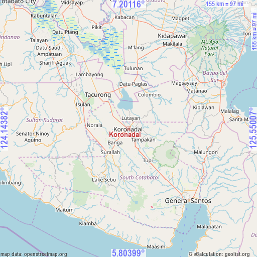
Koronadal GPS coordinates[2]
6° 30' 11.016" North, 124° 50' 48.984" East
| Map corner | latitude | longitude |
|---|---|---|
| Upper-left | 7.20116°, | 124.14382° |
| Center: | 6.50306°, | 124.84694° |
| Lower-right: | 5.80399°, | 125.55007° |
| Map W x H: | 155.4×155.4 km | = 96.6×96.6mi |
| max Lat: | 20.78733° ⇑95.6% North |
| Koronadal: | 6.50306° |
| min Lat: | ⇓4.4% South 4.65442° |
| min Long | Koronadal | max Long |
| 117.04868° | 124.84694° | 126.58417° |
| W 85.4%⇐ | ⇒14.6% E |
Elevation
Elevation of Koronadal is 52 m = 171 ft, and this is 35.9 m = 118 ft below average elevation for this country.
| Max E: |
2262 m = 7421 ft | 30% |
| Avg. | 87.9 m = 288 ft | |
| Koronadal | 52 m = 171 ft | |
Min E: |
-2 m = -7 ft | 70% |
See also: Koronadal elevation on elevation.city.
Geographical zone
Koronadal is located in North Torrid zone (between Equator and Tropic of Cancer). Distance of Equator is 723.1 km =449.3 mi to South.| Distance of | km | miles | from Koronadal |
|---|---|---|---|
| North Pole | 9284 | 5768.8 | to North |
| Arctic Circle | 6678.1 | 4149.6 | to North |
| Tropic Cancer | 1882.8 | 1169.9 | to North |
| Equator | 723.1 | 449.3 | to South |


Nearby cities:
15 places around Koronadal: (largest is in red/bold)
• Bañga
11.6 km =7.2 mi,  220°
220°
• Blingkong
10.6 km =6.6 mi,  26°
26°
• Bukay Pait
11 km =6.8 mi,  306°
306°
• Carpenter Hill
7.6 km =4.7 mi,  149°
149°
• Libas
7.4 km =4.6 mi,  284°
284°
• Lutayan
13.4 km =8.3 mi,  16°
16°
• Mabini
6.8 km =4.2 mi,  87°
87°
• Maibu
9.5 km =5.9 mi,  321°
321°
• Maindang
9.6 km =6 mi,  0°
0°
• Maltana
13.3 km =8.3 mi,  131°
131°
• New Iloilo
8.1 km =5 mi, 308°
• Paraiso
5.1 km =3.2 mi,  233°
233°
• Rotonda
4.5 km =2.8 mi,  106°
106°
• San Vicente
9.2 km =5.7 mi, 233°
• Tamnag
8.6 km =5.3 mi, 25°
Sources, notices
• [Note1] Compared only with cities in Philippines existing in our database
• [Src1] Map data: © OpenStreetMap contributors (CC-BY-SA)
• [Src2] Other city data from geonames.org with taken over terms of usage.
• [Src3] Geographical zone / Annual Mean Temperature by Robert A. Rohde @ Wikipedia
