Libas geodata
Libas (Soccsksargen) is a populated place; located in Philippines in Asia/Manila (GMT+8) time zone. With population of 2,153 people, there are 3984 cities with bigger population in this country. Compared to other cities in Philippines, 95.4% of cities are located further ↑North; 83.8% of cities are located further ←West and 78.5% of cities have lower elevation than Libas. Note1
Administrative division(s):
- Level 1: Soccsksargen
- Level 2: Province of South Cotabato
- Level 3: Tantangan


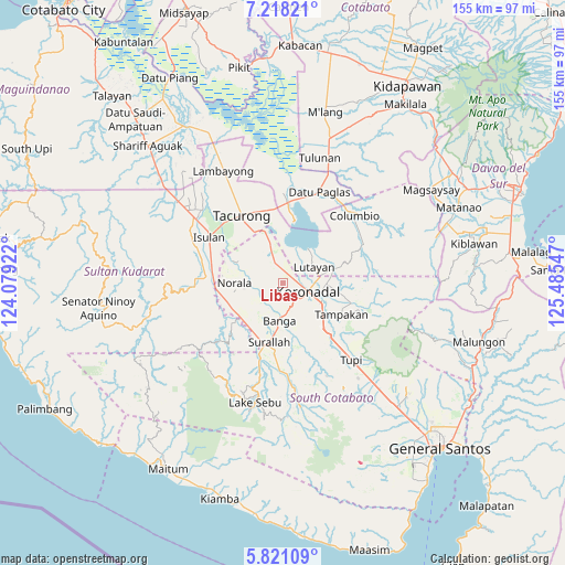
Libas GPS coordinates[2]
6° 31' 12.504" North, 124° 46' 56.424" East
| Map corner | latitude | longitude |
|---|---|---|
| Upper-left | 7.21821°, | 124.07922° |
| Center: | 6.52014°, | 124.78234° |
| Lower-right: | 5.82109°, | 125.48547° |
| Map W x H: | 155.3×155.3 km | = 96.5×96.5mi |
| max Lat: | 20.78733° ⇑95.4% North |
| Libas: | 6.52014° |
| min Lat: | ⇓4.6% South 4.65442° |
| min Long | Libas | max Long |
| 117.04868° | 124.78234° | 126.58417° |
| W 83.8%⇐ | ⇒16.2% E |
Elevation
Elevation of Libas is 82 m = 269 ft, and this is 5.9 m = 19 ft below average elevation for this country.
| Max E: |
2262 m = 7421 ft | 21.5% |
| Avg. | 87.9 m = 288 ft | |
| Libas | 82 m = 269 ft | |
Min E: |
-2 m = -7 ft | 78.5% |
See also: Philippines elevation on elevation.city.
Geographical zone
Libas is located in North Torrid zone (between Equator and Tropic of Cancer). Distance of Equator is 725 km =450.5 mi to South.| Distance of | km | miles | from Libas |
|---|---|---|---|
| North Pole | 9282.1 | 5767.6 | to North |
| Arctic Circle | 6676.2 | 4148.4 | to North |
| Tropic Cancer | 1880.9 | 1168.7 | to North |
| Equator | 725 | 450.5 | to South |


Nearby cities:
15 places around Libas: (largest is in red/bold)
• Bañga
10.7 km =6.6 mi,  182°
182°
• Bukay Pait
4.9 km =3 mi,  339°
339°
• Esperanza
12.9 km =8 mi,  259°
259°
• Guinsang-an
12.4 km =7.7 mi,  240°
240°
• Koronadal
7.4 km =4.6 mi,  104°
104°
• Lopez Jaena
10.5 km =6.5 mi, 242°
• Maibu
5.7 km =3.5 mi,  12°
12°
• Maindang
10.6 km =6.6 mi,  42°
42°
• New Iloilo
3.2 km =2 mi, 14°
• Paraiso
5.7 km =3.5 mi,  148°
148°
• Rotonda
11.9 km =7.4 mi,  105°
105°
• San Miguel
10 km =6.2 mi,  252°
252°
• San Vicente
7.4 km =4.6 mi, 181°
• Tamnag
12.3 km =7.6 mi,  61°
61°
• Tantangan
11.2 km =7 mi, 340°
Sources, notices
• [Note1] Compared only with cities in Philippines existing in our database
• [Src1] Map data: © OpenStreetMap contributors (CC-BY-SA)
• [Src2] Other city data from geonames.org with taken over terms of usage.
• [Src3] Geographical zone / Annual Mean Temperature by Robert A. Rohde @ Wikipedia
