Bukay Pait geodata
Bukay Pait (Soccsksargen) is a populated place; located in Philippines in Asia/Manila (GMT+8) time zone. With population of 3,356 people, there are 2180 cities with bigger population in this country. Compared to other cities in Philippines, 95.2% of cities are located further ↑North; 83.5% of cities are located further ←West and 62.9% of cities have lower elevation than Bukay Pait. Note1
Administrative division(s):
- Level 1: Soccsksargen
- Level 2: Province of South Cotabato
- Level 3: Tantangan


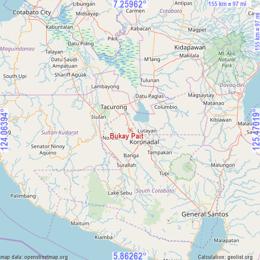
Bukay Pait GPS coordinates[2]
6° 33' 41.796" North, 124° 46' 1.416" East
| Map corner | latitude | longitude |
|---|---|---|
| Upper-left | 7.25962°, | 124.06394° |
| Center: | 6.56161°, | 124.76706° |
| Lower-right: | 5.86262°, | 125.47019° |
| Map W x H: | 155.3×155.3 km | = 96.5×96.5mi |
| max Lat: | 20.78733° ⇑95.2% North |
| Bukay Pait: | 6.56161° |
| min Lat: | ⇓4.8% South 4.65442° |
| min Long | Bukay Pait | max Long |
| 117.04868° | 124.76706° | 126.58417° |
| W 83.5%⇐ | ⇒16.5% E |
Elevation
Elevation of Bukay Pait is 38 m = 125 ft, and this is 49.9 m = 164 ft below average elevation for this country.
| Max E: |
2262 m = 7421 ft | 37.1% |
| Avg. | 87.9 m = 288 ft | |
| Bukay Pait | 38 m = 125 ft | |
Min E: |
-2 m = -7 ft | 62.9% |
See also: Philippines elevation on elevation.city.
Geographical zone
Bukay Pait is located in North Torrid zone (between Equator and Tropic of Cancer). Distance of Equator is 729.6 km =453.4 mi to South.| Distance of | km | miles | from Bukay Pait |
|---|---|---|---|
| North Pole | 9277.5 | 5764.8 | to North |
| Arctic Circle | 6671.6 | 4145.5 | to North |
| Tropic Cancer | 1876.3 | 1165.9 | to North |
| Equator | 729.6 | 453.4 | to South |


Nearby cities:
15 places around Bukay Pait: (largest is in red/bold)
• Blingkong
13.8 km =8.6 mi,  77°
77°
• Esperanza
13.1 km =8.1 mi,  237°
237°
• Kalandagan
13.8 km =8.6 mi,  340°
340°
• Koronadal
11 km =6.8 mi,  126°
126°
• Libas
4.9 km =3 mi,  159°
159°
• Lopez Jaena
12.2 km =7.6 mi,  218°
218°
• Maibu
3.1 km =1.9 mi,  72°
72°
• Maindang
9.4 km =5.8 mi, 70°
• New Iloilo
2.9 km =1.8 mi,  121°
121°
• Norala
12.7 km =7.9 mi,  249°
249°
• Paraiso
10.6 km =6.6 mi,  153°
153°
• San Miguel
11 km =6.8 mi,  225°
225°
• San Vicente
12.1 km =7.5 mi,  173°
173°
• Tamnag
12.5 km =7.8 mi, 84°
• Tantangan
6.3 km =3.9 mi, 341°
Sources, notices
• [Note1] Compared only with cities in Philippines existing in our database
• [Src1] Map data: © OpenStreetMap contributors (CC-BY-SA)
• [Src2] Other city data from geonames.org with taken over terms of usage.
• [Src3] Geographical zone / Annual Mean Temperature by Robert A. Rohde @ Wikipedia
