Santo Niño geodata
Santo Niño (Eastern Visayas) is a populated place; located in Philippines in Asia/Manila (GMT+8) time zone. With population of 2,012 people, there are 4157 cities with bigger population in this country. Compared to other cities in Philippines, 56.1% of cities are located further ↑North; 79.8% of cities are located further ←West and 76.6% of cities have higher elevation than Santo Niño. Note1


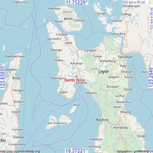
Santo Niño GPS coordinates[2]
11° 3' 47.016" North, 124° 33' 42.012" East
| Map corner | latitude | longitude |
|---|---|---|
| Upper-left | 11.75229°, | 123.85855° |
| Center: | 11.06306°, | 124.56167° |
| Lower-right: | 10.37221°, | 125.2648° |
| Map W x H: | 153.5×153.5 km | = 95.4×95.4mi |
| max Lat: | 20.78733° ⇑56.1% North |
| Santo Niño: | 11.06306° |
| min Lat: | ⇓43.9% South 4.65442° |
| min Long | Santo Niño | max Long |
| 117.04868° | 124.56167° | 126.58417° |
| W 79.8%⇐ | ⇒20.2% E |
Elevation
Elevation of Santo Niño is 10 m = 33 ft, and this is 77.9 m = 256 ft below average elevation for this country.
| Max E: |
2262 m = 7421 ft | 76.6% |
| Avg. | 87.9 m = 288 ft | |
| Santo Niño | 10 m = 33 ft | |
Min E: |
-2 m = -7 ft | 23.4% |
See also: Philippines elevation on elevation.city.
Geographical zone
Santo Niño is located in North Torrid zone (between Equator and Tropic of Cancer). Distance of Equator is 1230.1 km =764.3 mi to South.| Distance of | km | miles | from Santo Niño |
|---|---|---|---|
| North Pole | 8777 | 5453.8 | to North |
| Arctic Circle | 6171.1 | 3834.5 | to North |
| Tropic Cancer | 1375.8 | 854.9 | to North |
| Equator | 1230.1 | 764.3 | to South |


Nearby cities:
15 places around Santo Niño: (largest is in red/bold)
• Balagtas
9.1 km =5.7 mi,  329°
329°
• Dolores
5.6 km =3.5 mi,  91°
91°
• Lao
5 km =3.1 mi,  182°
182°
• Libertad
3.1 km =1.9 mi,  166°
166°
• Liloan
2.4 km =1.5 mi,  209°
209°
• Malilinao
8.2 km =5.1 mi,  306°
306°
• Margen
6.3 km =3.9 mi,  215°
215°
• Masarayao
6.8 km =4.2 mi,  64°
64°
• Naghalin
9.2 km =5.7 mi,  3°
3°
• Ormoc
8 km =5 mi,  141°
141°
• Puerto Bello
10.4 km =6.5 mi,  196°
196°
• San Juan
7.4 km =4.6 mi, 199°
• San Vicente
6.2 km =3.9 mi, 4°
• Tugbong
6.6 km =4.1 mi, 140°
• Valencia
5.2 km =3.2 mi,  13°
13°
Sources, notices
• [Note1] Compared only with cities in Philippines existing in our database
• [Src1] Map data: © OpenStreetMap contributors (CC-BY-SA)
• [Src2] Other city data from geonames.org with taken over terms of usage.
• [Src3] Geographical zone / Annual Mean Temperature by Robert A. Rohde @ Wikipedia
