Dolores geodata
Dolores (Eastern Visayas) is a populated place; located in Philippines in Asia/Manila (GMT+8) time zone. With population of 2,265 people, there are 3756 cities with bigger population in this country. Compared to other cities in Philippines, 56.2% of cities are located further ↑North; 81.1% of cities are located further ←West and 87.5% of cities have lower elevation than Dolores. Note1


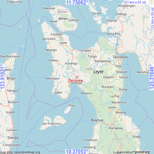
Dolores GPS coordinates[2]
11° 3' 41.004" North, 124° 36' 47.988" East
| Map corner | latitude | longitude |
|---|---|---|
| Upper-left | 11.75062°, | 123.91021° |
| Center: | 11.06139°, | 124.61333° |
| Lower-right: | 10.37053°, | 125.31646° |
| Map W x H: | 153.5×153.5 km | = 95.4×95.4mi |
| max Lat: | 20.78733° ⇑56.2% North |
| Dolores: | 11.06139° |
| min Lat: | ⇓43.8% South 4.65442° |
| min Long | Dolores | max Long |
| 117.04868° | 124.61333° | 126.58417° |
| W 81.1%⇐ | ⇒18.9% E |
Elevation
Elevation of Dolores is 174 m = 571 ft, and this is 86.1 m = 282 ft above average elevation for this country.
| Max E: |
2262 m = 7421 ft | 12.5% |
| Dolores | 174 m 571 ft | |
| Avg. | 87.9 m = 288 ft | |
Min E: |
-2 m = -7 ft | 87.5% |
See also: Philippines elevation on elevation.city.
Geographical zone
Dolores is located in North Torrid zone (between Equator and Tropic of Cancer). Distance of Equator is 1229.9 km =764.2 mi to South.| Distance of | km | miles | from Dolores |
|---|---|---|---|
| North Pole | 8777.2 | 5453.9 | to North |
| Arctic Circle | 6171.3 | 3834.7 | to North |
| Tropic Cancer | 1376 | 855 | to North |
| Equator | 1229.9 | 764.2 | to South |


Nearby cities:
15 places around Dolores: (largest is in red/bold)
• Ipil
10 km =6.2 mi,  165°
165°
• Lao
7.6 km =4.7 mi,  230°
230°
• Libertad
5.6 km =3.5 mi,  240°
240°
• Liloan
7.1 km =4.4 mi,  254°
254°
• Lim-oo
10.1 km =6.3 mi,  10°
10°
• Margen
10.5 km =6.5 mi, 242°
• Masarayao
3.2 km =2 mi, 8°
• Naghalin
10.6 km =6.6 mi,  331°
331°
• Ormoc
6.1 km =3.8 mi,  185°
185°
• Puerto Bello
13 km =8.1 mi,  221°
221°
• San Juan
10.5 km =6.5 mi, 230°
• San Vicente
8.2 km =5.1 mi,  320°
320°
• Santo Niño
5.6 km =3.5 mi,  271°
271°
• Tugbong
5.2 km =3.2 mi,  196°
196°
• Valencia
6.9 km =4.3 mi, 319°
Sources, notices
• [Note1] Compared only with cities in Philippines existing in our database
• [Src1] Map data: © OpenStreetMap contributors (CC-BY-SA)
• [Src2] Other city data from geonames.org with taken over terms of usage.
• [Src3] Geographical zone / Annual Mean Temperature by Robert A. Rohde @ Wikipedia
