Santiago geodata
Santiago (Davao) is a populated place; located in Philippines in Asia/Manila (GMT+8) time zone. With population of 2,631 people, there are 3061 cities with bigger population in this country. Compared to other cities in Philippines, 88.7% of cities are located further ↑North; 100% of cities are located further ←West and 68.9% of cities have lower elevation than Santiago. Note1


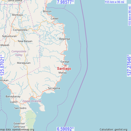
Santiago GPS coordinates[2]
7° 17' 20.004" North, 126° 34' 23.988" East
| Map corner | latitude | longitude |
|---|---|---|
| Upper-left | 7.98577°, | 125.87021° |
| Center: | 7.28889°, | 126.57333° |
| Lower-right: | 6.59092°, | 127.27646° |
| Map W x H: | 155.1×155.1 km | = 96.4×96.4mi |
| max Lat: | 20.78733° ⇑88.7% North |
| Santiago: | 7.28889° |
| min Lat: | ⇓11.3% South 4.65442° |
| min Long | Santiago | max Long |
| 117.04868° | 126.57333° | 126.58417° |
| W 100%⇐ | ⇒0% E |
Elevation
Elevation of Santiago is 50 m = 164 ft, and this is 37.9 m = 124 ft below average elevation for this country.
| Max E: |
2262 m = 7421 ft | 31.1% |
| Avg. | 87.9 m = 288 ft | |
| Santiago | 50 m = 164 ft | |
Min E: |
-2 m = -7 ft | 68.9% |
See also: Philippines elevation on elevation.city.
Geographical zone
Santiago is located in North Torrid zone (between Equator and Tropic of Cancer). Distance of Equator is 810.4 km =503.6 mi to South.| Distance of | km | miles | from Santiago |
|---|---|---|---|
| North Pole | 9196.6 | 5714.5 | to North |
| Arctic Circle | 6590.7 | 4095.3 | to North |
| Tropic Cancer | 1795.5 | 1115.7 | to North |
| Equator | 810.4 | 503.6 | to South |


Nearby cities:
15 places around Santiago: (largest is in red/bold)
• Baculin
18.2 km =11.3 mi,  3°
3°
• Baganga
31.7 km =19.7 mi,  357°
357°
• Batiano
30.8 km =19.1 mi,  342°
342°
• Caraga
4.6 km =2.9 mi,  351°
351°
• Jovellar
28.2 km =17.5 mi,  207°
207°
• Kinablangan
45 km =28 mi, 356°
• Limot
43.2 km =26.8 mi,  230°
230°
• Lukatan
35.3 km =21.9 mi, 208°
• Mahanob
32.5 km =20.2 mi, 346°
• Manay
9 km =5.6 mi,  204°
204°
• Mayo
41.5 km =25.8 mi,  219°
219°
• San Ignacio
21.1 km =13.1 mi, 206°
• San Luis
17.1 km =10.6 mi, 351°
• San Pedro
8.5 km =5.3 mi,  313°
313°
• Tarragona
30.1 km =18.7 mi, 207°
Sources, notices
• [Note1] Compared only with cities in Philippines existing in our database
• [Src1] Map data: © OpenStreetMap contributors (CC-BY-SA)
• [Src2] Other city data from geonames.org with taken over terms of usage.
• [Src3] Geographical zone / Annual Mean Temperature by Robert A. Rohde @ Wikipedia
