Tarragona geodata
Tarragona (Davao) is a seat of a third-order administrative division; located in Philippines in Asia/Manila (GMT+8) time zone. With population of 3,777 people, there are 1864 cities with bigger population in this country. Compared to other cities in Philippines, 91.2% of cities are located further ↑North; 99.7% of cities are located further ←West and 53.1% of cities have higher elevation than Tarragona. Note1


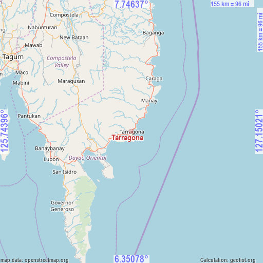
Tarragona GPS coordinates[2]
7° 2' 56.76" North, 126° 26' 49.488" East
| Map corner | latitude | longitude |
|---|---|---|
| Upper-left | 7.74637°, | 125.74396° |
| Center: | 7.0491°, | 126.44708° |
| Lower-right: | 6.35078°, | 127.15021° |
| Map W x H: | 155.2×155.2 km | = 96.4×96.4mi |
| max Lat: | 20.78733° ⇑91.2% North |
| Tarragona: | 7.0491° |
| min Lat: | ⇓8.8% South 4.65442° |
| min Long | Tarragona | max Long |
| 117.04868° | 126.44708° | 126.58417° |
| W 99.7%⇐ | ⇒0.3% E |
Elevation
Elevation of Tarragona is 21 m = 69 ft, and this is 66.9 m = 219 ft below average elevation for this country.
| Max E: |
2262 m = 7421 ft | 53.1% |
| Avg. | 87.9 m = 288 ft | |
| Tarragona | 21 m = 69 ft | |
Min E: |
-2 m = -7 ft | 46.9% |
See also: Philippines elevation on elevation.city.
Geographical zone
Tarragona is located in North Torrid zone (between Equator and Tropic of Cancer). Distance of Equator is 783.8 km =487 mi to South.| Distance of | km | miles | from Tarragona |
|---|---|---|---|
| North Pole | 9223.3 | 5731.1 | to North |
| Arctic Circle | 6617.4 | 4111.9 | to North |
| Tropic Cancer | 1822.1 | 1132.2 | to North |
| Equator | 783.8 | 487 | to South |


Nearby cities:
15 places around Tarragona: (largest is in red/bold)
• Bobon
24 km =14.9 mi,  213°
213°
• Caraga
33.9 km =21.1 mi,  23°
23°
• Davan
35.7 km =22.2 mi,  245°
245°
• Ilangay
46.4 km =28.8 mi, 250°
• Jovellar
1.9 km =1.2 mi,  30°
30°
• Limot
19.3 km =12 mi,  267°
267°
• Lukatan
5.2 km =3.2 mi, 213°
• Manay
21.1 km =13.1 mi, 28°
• Mati
27.5 km =17.1 mi, 247°
• Mayo
13.7 km =8.5 mi, 247°
• San Ignacio
9 km =5.6 mi, 30°
• San Luis
45.1 km =28 mi,  14°
14°
• San Pedro
33.5 km =20.8 mi, 13°
• Santiago
30.1 km =18.7 mi, 27°
• Tamisan
28.1 km =17.5 mi,  215°
215°
Sources, notices
• [Note1] Compared only with cities in Philippines existing in our database
• [Src1] Map data: © OpenStreetMap contributors (CC-BY-SA)
• [Src2] Other city data from geonames.org with taken over terms of usage.
• [Src3] Geographical zone / Annual Mean Temperature by Robert A. Rohde @ Wikipedia
