Kinablangan geodata
Kinablangan (Davao) is a populated place; located in Philippines in Asia/Manila (GMT+8) time zone. With population of 5,423 people, there are 1171 cities with bigger population in this country. Compared to other cities in Philippines, 85.2% of cities are located further ↑North; 99.9% of cities are located further ←West and 67.4% of cities have higher elevation than Kinablangan. Note1


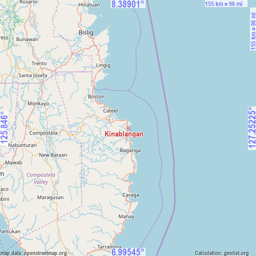
Kinablangan GPS coordinates[2]
7° 41' 34.08" North, 126° 32' 56.832" East
| Map corner | latitude | longitude |
|---|---|---|
| Upper-left | 8.38901°, | 125.846° |
| Center: | 7.6928°, | 126.54912° |
| Lower-right: | 6.99545°, | 127.25225° |
| Map W x H: | 154.9×155 km | = 96.3×96.3mi |
| max Lat: | 20.78733° ⇑85.2% North |
| Kinablangan: | 7.6928° |
| min Lat: | ⇓14.8% South 4.65442° |
| min Long | Kinablangan | max Long |
| 117.04868° | 126.54912° | 126.58417° |
| W 99.9%⇐ | ⇒0.099999999999994% E |
Elevation
Elevation of Kinablangan is 13 m = 43 ft, and this is 74.9 m = 246 ft below average elevation for this country.
| Max E: |
2262 m = 7421 ft | 67.4% |
| Avg. | 87.9 m = 288 ft | |
| Kinablangan | 13 m = 43 ft | |
Min E: |
-2 m = -7 ft | 32.6% |
See also: Philippines elevation on elevation.city.
Geographical zone
Kinablangan is located in North Torrid zone (between Equator and Tropic of Cancer). Distance of Equator is 855.4 km =531.5 mi to South.| Distance of | km | miles | from Kinablangan |
|---|---|---|---|
| North Pole | 9151.7 | 5686.6 | to North |
| Arctic Circle | 6545.8 | 4067.4 | to North |
| Tropic Cancer | 1750.6 | 1087.8 | to North |
| Equator | 855.4 | 531.5 | to South |


Nearby cities:
15 places around Kinablangan: (largest is in red/bold)
• Baculin
27 km =16.8 mi,  171°
171°
• Baganga
13.3 km =8.3 mi, 174°
• Batiano
16.8 km =10.4 mi,  202°
202°
• Boston
28.4 km =17.6 mi,  314°
314°
• Caraga
40.4 km =25.1 mi,  177°
177°
• Cateel
15.2 km =9.4 mi,  316°
316°
• Lingig
41.3 km =25.7 mi,  338°
338°
• Mahanob
14.1 km =8.8 mi, 199°
• San Alfonso
17.2 km =10.7 mi,  304°
304°
• San Luis
28 km =17.4 mi, 179°
• San Pedro
39.2 km =24.4 mi,  185°
185°
• San Rafael
13 km =8.1 mi, 307°
• Santa Maria
35.2 km =21.9 mi, 340°
• Santiago
45 km =28 mi, 176°
• Taytayan
6.9 km =4.3 mi, 311°
Sources, notices
• [Note1] Compared only with cities in Philippines existing in our database
• [Src1] Map data: © OpenStreetMap contributors (CC-BY-SA)
• [Src2] Other city data from geonames.org with taken over terms of usage.
• [Src3] Geographical zone / Annual Mean Temperature by Robert A. Rohde @ Wikipedia
