Limot geodata
Limot (Davao) is a populated place; located in Philippines in Asia/Manila (GMT+8) time zone. With population of 2,221 people, there are 3846 cities with bigger population in this country. Compared to other cities in Philippines, 91.3% of cities are located further ↑North; 99.2% of cities are located further ←West and 89.7% of cities have lower elevation than Limot. Note1
Administrative division(s):
- Level 1: Davao
- Level 2: Province of Davao Oriental
- Level 3: City of Mati


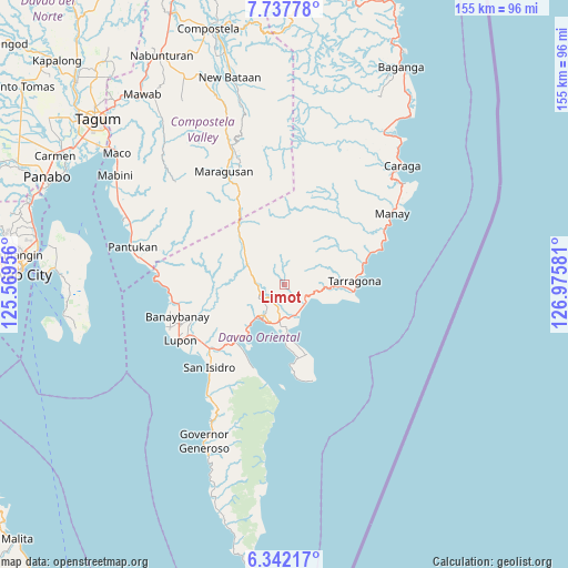
Limot GPS coordinates[2]
7° 2' 25.8" North, 126° 16' 21.648" East
| Map corner | latitude | longitude |
|---|---|---|
| Upper-left | 7.73778°, | 125.56956° |
| Center: | 7.0405°, | 126.27268° |
| Lower-right: | 6.34217°, | 126.97581° |
| Map W x H: | 155.2×155.2 km | = 96.4×96.4mi |
| max Lat: | 20.78733° ⇑91.3% North |
| Limot: | 7.0405° |
| min Lat: | ⇓8.7% South 4.65442° |
| min Long | Limot | max Long |
| 117.04868° | 126.27268° | 126.58417° |
| W 99.2%⇐ | ⇒0.8% E |
Elevation
Elevation of Limot is 221 m = 725 ft, and this is 133.1 m = 437 ft above average elevation for this country.
| Max E: |
2262 m = 7421 ft | 10.3% |
| Limot | 221 m 725 ft | |
| Avg. | 87.9 m = 288 ft | |
Min E: |
-2 m = -7 ft | 89.7% |
See also: Philippines elevation on elevation.city.
Geographical zone
Limot is located in North Torrid zone (between Equator and Tropic of Cancer). Distance of Equator is 782.8 km =486.4 mi to South.| Distance of | km | miles | from Limot |
|---|---|---|---|
| North Pole | 9224.2 | 5731.7 | to North |
| Arctic Circle | 6618.3 | 4112.4 | to North |
| Tropic Cancer | 1823.1 | 1132.8 | to North |
| Equator | 782.8 | 486.4 | to South |


Nearby cities:
15 places around Limot: (largest is in red/bold)
• Banaybanay
29.5 km =18.3 mi,  252°
252°
• Batobato
31.7 km =19.7 mi,  220°
220°
• Bobon
20.2 km =12.6 mi,  162°
162°
• Davan
19.2 km =11.9 mi, 223°
• Ilangay
28.4 km =17.6 mi,  239°
239°
• Jovellar
20.3 km =12.6 mi,  82°
82°
• Linao
31.1 km =19.3 mi,  265°
265°
• Lukatan
16.7 km =10.4 mi,  101°
101°
• Manikling
29.5 km =18.3 mi,  232°
232°
• Mati
11.3 km =7 mi,  213°
213°
• Mayo
7.8 km =4.8 mi,  123°
123°
• Panikian
27.6 km =17.1 mi,  263°
263°
• San Ignacio
25.3 km =15.7 mi,  69°
69°
• Tamisan
22.1 km =13.7 mi,  172°
172°
• Tarragona
19.3 km =12 mi,  87°
87°
Sources, notices
• [Note1] Compared only with cities in Philippines existing in our database
• [Src1] Map data: © OpenStreetMap contributors (CC-BY-SA)
• [Src2] Other city data from geonames.org with taken over terms of usage.
• [Src3] Geographical zone / Annual Mean Temperature by Robert A. Rohde @ Wikipedia
