Mayo geodata
Mayo (Davao) is a populated place; located in Philippines in Asia/Manila (GMT+8) time zone. With population of 2,829 people, there are 2742 cities with bigger population in this country. Compared to other cities in Philippines, 91.7% of cities are located further ↑North; 99.4% of cities are located further ←West and 60.8% of cities have higher elevation than Mayo. Note1
Administrative division(s):
- Level 1: Davao
- Level 2: Province of Davao Oriental
- Level 3: City of Mati


Mayo GPS coordinates[2]
7° 0' 7.596" North, 126° 19' 55.128" East
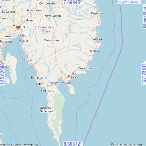
| Map corner | latitude | longitude |
|---|---|---|
| Upper-left | 7.69945°, | 125.62886° |
| Center: | 7.00211°, | 126.33198° |
| Lower-right: | 6.30372°, | 127.03511° |
| Map W x H: | 155.2×155.2 km | = 96.4×96.4mi |
| max Lat: | 20.78733° ⇑91.7% North |
| Mayo: | 7.00211° |
| min Lat: | ⇓8.3% South 4.65442° |
| min Long | Mayo | max Long |
| 117.04868° | 126.33198° | 126.58417° |
| W 99.4%⇐ | ⇒0.59999999999999% E |
Elevation
Elevation of Mayo is 16 m = 52 ft, and this is 71.9 m = 236 ft below average elevation for this country.
| Max E: |
2262 m = 7421 ft | 60.8% |
| Avg. | 87.9 m = 288 ft | |
| Mayo | 16 m = 52 ft | |
Min E: |
-2 m = -7 ft | 39.2% |
See also: Philippines elevation on elevation.city.
Geographical zone
Mayo is located in North Torrid zone (between Equator and Tropic of Cancer). Distance of Equator is 778.6 km =483.8 mi to South.| Distance of | km | miles | from Mayo |
|---|---|---|---|
| North Pole | 9228.5 | 5734.3 | to North |
| Arctic Circle | 6622.6 | 4115.1 | to North |
| Tropic Cancer | 1827.4 | 1135.5 | to North |
| Equator | 778.6 | 483.8 | to South |


Nearby cities:
15 places around Mayo: (largest is in red/bold)
• Banaybanay
35 km =21.7 mi,  262°
262°
• Batobato
33.7 km =20.9 mi,  234°
234°
• Bobon
14.9 km =9.3 mi,  181°
181°
• Davan
22 km =13.7 mi,  243°
243°
• Ilangay
32.7 km =20.3 mi,  252°
252°
• Jovellar
15.3 km =9.5 mi,  63°
63°
• Limot
7.8 km =4.8 mi,  303°
303°
• Lukatan
9.9 km =6.2 mi,  85°
85°
• Manay
32.9 km =20.4 mi,  44°
44°
• Manikling
32.9 km =20.4 mi, 245°
• Mati
13.8 km =8.6 mi, 247°
• Panikian
34 km =21.1 mi,  271°
271°
• San Ignacio
21.6 km =13.4 mi,  53°
53°
• Tamisan
18 km =11.2 mi,  191°
191°
• Tarragona
13.7 km =8.5 mi,  67°
67°
Sources, notices
• [Note1] Compared only with cities in Philippines existing in our database
• [Src1] Map data: © OpenStreetMap contributors (CC-BY-SA)
• [Src2] Other city data from geonames.org with taken over terms of usage.
• [Src3] Geographical zone / Annual Mean Temperature by Robert A. Rohde @ Wikipedia
