San Teodoro geodata
San Teodoro (Mimaropa) is a populated place; located in Philippines in Asia/Manila (GMT+8) time zone. With population of 4,827 people, there are 1365 cities with bigger population in this country. Compared to other cities in Philippines, 61.6% of cities are located further ↓South; 76% of cities are located further →East and 76.2% of cities have lower elevation than San Teodoro. Note1
Administrative division(s):
- Level 1: Mimaropa
- Level 2: Province of Mindoro Oriental
- Level 3: San Teodoro


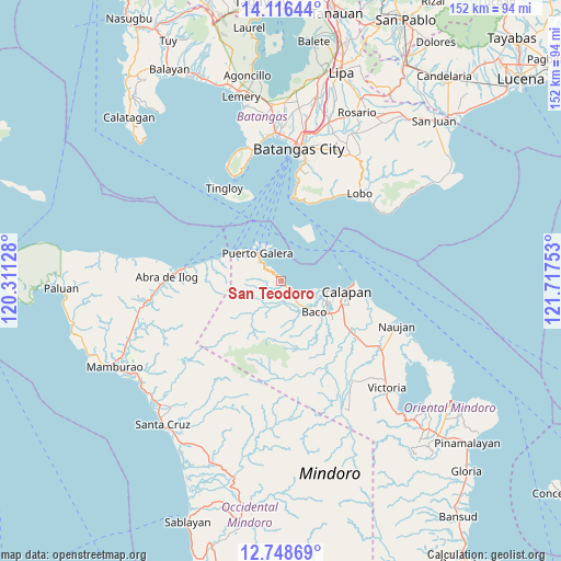
San Teodoro GPS coordinates[2]
13° 26' 0.744" North, 121° 0' 51.84" East
| Map corner | latitude | longitude |
|---|---|---|
| Upper-left | 14.11644°, | 120.31128° |
| Center: | 13.43354°, | 121.0144° |
| Lower-right: | 12.74869°, | 121.71753° |
| Map W x H: | 152.1×152.1 km | = 94.5×94.5mi |
| max Lat: | 20.78733° ⇑38.4% North |
| San Teodoro: | 13.43354° |
| min Lat: | ⇓61.6% South 4.65442° |
| min Long | San Teodoro | max Long |
| 117.04868° | 121.0144° | 126.58417° |
| W 24%⇐ | ⇒76% E |
Elevation
Elevation of San Teodoro is 73 m = 240 ft, and this is 14.9 m = 49 ft below average elevation for this country.
| Max E: |
2262 m = 7421 ft | 23.8% |
| Avg. | 87.9 m = 288 ft | |
| San Teodoro | 73 m = 240 ft | |
Min E: |
-2 m = -7 ft | 76.2% |
See also: Philippines elevation on elevation.city.
Geographical zone
San Teodoro is located in North Torrid zone (between Equator and Tropic of Cancer). Distance of this Northern Tropic circle is 1112.2 km =691.1 mi to North.| Distance of | km | miles | from San Teodoro |
|---|---|---|---|
| North Pole | 8513.4 | 5290 | to North |
| Arctic Circle | 5907.5 | 3670.7 | to North |
| Tropic Cancer | 1112.2 | 691.1 | to North |
| Equator | 1493.7 | 928.1 | to South |


Nearby cities:
15 places around San Teodoro: (largest is in red/bold)
• Baco
12.4 km =7.7 mi,  133°
133°
• Balatero
12.4 km =7.7 mi,  308°
308°
• Bayanan
18.7 km =11.6 mi,  116°
116°
• Calapan
18.1 km =11.2 mi,  97°
97°
• Canubing No 2
15.9 km =9.9 mi, 125°
• Dulangan
5.4 km =3.4 mi,  316°
316°
• Dulangan
17.8 km =11.1 mi,  143°
143°
• Evangelista
14.3 km =8.9 mi, 141°
• Lumangbayan
2.7 km =1.7 mi, 126°
• Puerto Galera
10.2 km =6.3 mi, 318°
• Sabang
9.5 km =5.9 mi,  332°
332°
• San Vincente
17.6 km =10.9 mi, 99°
• Sapol
20.4 km =12.7 mi,  111°
111°
• Tabinay
8.6 km =5.3 mi, 313°
• Tacligan
6.6 km =4.1 mi, 127°
Sources, notices
• [Note1] Compared only with cities in Philippines existing in our database
• [Src1] Map data: © OpenStreetMap contributors (CC-BY-SA)
• [Src2] Other city data from geonames.org with taken over terms of usage.
• [Src3] Geographical zone / Annual Mean Temperature by Robert A. Rohde @ Wikipedia
