Santa Teresita geodata
Santa Teresita (Cagayan Valley) is a seat of a third-order administrative division; located in Philippines in Asia/Manila (GMT+8) time zone. With population of 2,576 people, there are 3152 cities with bigger population in this country. Compared to other cities in Philippines, 99.1% of cities are located further ↓South; 61.5% of cities are located further →East and 73.2% of cities have higher elevation than Santa Teresita. Note1
Administrative division(s):
- Level 1: Cagayan Valley
- Level 2: Province of Cagayan
- Level 3: Santa Teresita


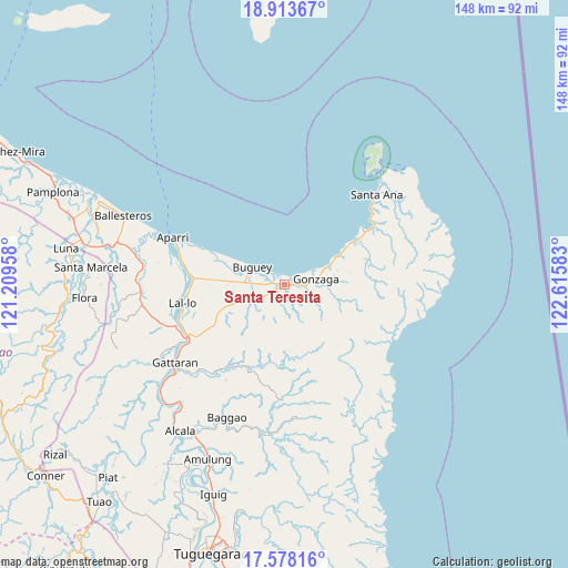
Santa Teresita GPS coordinates[2]
18° 14' 49.92" North, 121° 54' 45.72" East
| Map corner | latitude | longitude |
|---|---|---|
| Upper-left | 18.91367°, | 121.20958° |
| Center: | 18.2472°, | 121.9127° |
| Lower-right: | 17.57816°, | 122.61583° |
| Map W x H: | 148.5×148.5 km | = 92.3×92.3mi |
| max Lat: | 20.78733° ⇑0.9% North |
| Santa Teresita: | 18.2472° |
| min Lat: | ⇓99.1% South 4.65442° |
| min Long | Santa Teresita | max Long |
| 117.04868° | 121.9127° | 126.58417° |
| W 38.5%⇐ | ⇒61.5% E |
Elevation
Elevation of Santa Teresita is 11 m = 36 ft, and this is 76.9 m = 252 ft below average elevation for this country.
| Max E: |
2262 m = 7421 ft | 73.2% |
| Avg. | 87.9 m = 288 ft | |
| Santa Teresita | 11 m = 36 ft | |
Min E: |
-2 m = -7 ft | 26.8% |
See also: Philippines elevation on elevation.city.
Geographical zone
Santa Teresita is located in North Torrid zone (between Equator and Tropic of Cancer). Distance of this Northern Tropic circle is 577 km =358.5 mi to North.| Distance of | km | miles | from Santa Teresita |
|---|---|---|---|
| North Pole | 7978.2 | 4957.4 | to North |
| Arctic Circle | 5372.3 | 3338.2 | to North |
| Tropic Cancer | 577 | 358.5 | to North |
| Equator | 2028.9 | 1260.7 | to South |


Nearby cities:
15 places around Santa Teresita: (largest is in red/bold)
• Bagumbayan
27 km =16.8 mi,  257°
257°
• Buguey
9.6 km =6 mi,  298°
298°
• Cabiraoan
20.2 km =12.6 mi,  65°
65°
• Camalaniugan
25.3 km =15.7 mi,  276°
276°
• Capissayan Sur
24 km =14.9 mi,  204°
204°
• Casambalangan
26.8 km =16.7 mi,  57°
57°
• Catayauan
29.1 km =18.1 mi,  250°
250°
• Gonzaga
8.8 km =5.5 mi,  81°
81°
• Magapit
28.5 km =17.7 mi,  244°
244°
• Maxingal
26.1 km =16.2 mi, 262°
• Paddaya
17 km =10.6 mi, 295°
• Paddaya
20.2 km =12.6 mi,  294°
294°
• Pattao
10.3 km =6.4 mi,  269°
269°
• Santa Maria
28.7 km =17.8 mi, 245°
• Tapel
13.1 km =8.1 mi, 69°
Sources, notices
• [Note1] Compared only with cities in Philippines existing in our database
• [Src1] Map data: © OpenStreetMap contributors (CC-BY-SA)
• [Src2] Other city data from geonames.org with taken over terms of usage.
• [Src3] Geographical zone / Annual Mean Temperature by Robert A. Rohde @ Wikipedia
