Cabiraoan geodata
Cabiraoan (Cagayan Valley) is a populated place; located in Philippines in Asia/Manila (GMT+8) time zone. With population of 2,932 people, there are 2606 cities with bigger population in this country. Compared to other cities in Philippines, 99.3% of cities are located further ↓South; 59.1% of cities are located further →East and 65.9% of cities have lower elevation than Cabiraoan. Note1


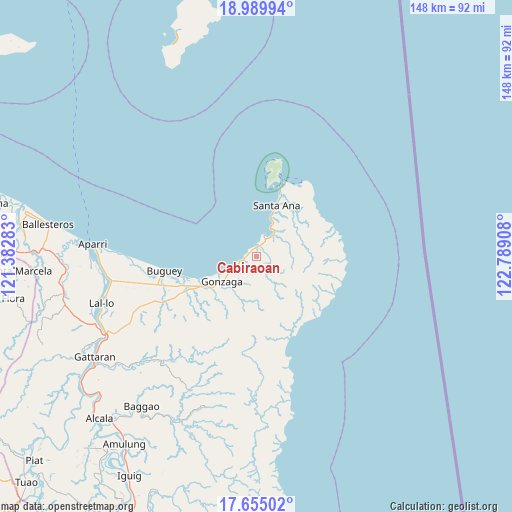
Cabiraoan GPS coordinates[2]
18° 19' 25.572" North, 122° 5' 9.42" East
| Map corner | latitude | longitude |
|---|---|---|
| Upper-left | 18.98994°, | 121.38283° |
| Center: | 18.32377°, | 122.08595° |
| Lower-right: | 17.65502°, | 122.78908° |
| Map W x H: | 148.4×148.4 km | = 92.2×92.2mi |
| max Lat: | 20.78733° ⇑0.7% North |
| Cabiraoan: | 18.32377° |
| min Lat: | ⇓99.3% South 4.65442° |
| min Long | Cabiraoan | max Long |
| 117.04868° | 122.08595° | 126.58417° |
| W 40.9%⇐ | ⇒59.1% E |
Elevation
Elevation of Cabiraoan is 43 m = 141 ft, and this is 44.9 m = 147 ft below average elevation for this country.
| Max E: |
2262 m = 7421 ft | 34.1% |
| Avg. | 87.9 m = 288 ft | |
| Cabiraoan | 43 m = 141 ft | |
Min E: |
-2 m = -7 ft | 65.9% |
See also: Philippines elevation on elevation.city.
Geographical zone
Cabiraoan is located in North Torrid zone (between Equator and Tropic of Cancer). Distance of this Northern Tropic circle is 568.5 km =353.2 mi to North.| Distance of | km | miles | from Cabiraoan |
|---|---|---|---|
| North Pole | 7969.6 | 4952.1 | to North |
| Arctic Circle | 5363.8 | 3332.9 | to North |
| Tropic Cancer | 568.5 | 353.2 | to North |
| Equator | 2037.4 | 1266 | to South |


Nearby cities:
15 places around Cabiraoan: (largest is in red/bold)
• Aparri
47.1 km =29.3 mi,  274°
274°
• Bagumbayan
46.9 km =29.1 mi,  252°
252°
• Buguey
27 km =16.8 mi,  261°
261°
• Camalaniugan
43.8 km =27.2 mi, 262°
• Capissayan Sur
41.5 km =25.8 mi,  223°
223°
• Casambalangan
7.3 km =4.5 mi,  36°
36°
• Gonzaga
12 km =7.5 mi,  233°
233°
• Maxingal
45.7 km =28.4 mi, 254°
• Paddaya
33.6 km =20.9 mi, 267°
• Paddaya
36.7 km =22.8 mi, 269°
• Pattao
29.9 km =18.6 mi, 253°
• San Vicente
21.5 km =13.4 mi,  18°
18°
• Santa Ana
17.5 km =10.9 mi, 21°
• Santa Teresita
20.2 km =12.6 mi, 245°
• Tapel
7.1 km =4.4 mi,  237°
237°
Sources, notices
• [Note1] Compared only with cities in Philippines existing in our database
• [Src1] Map data: © OpenStreetMap contributors (CC-BY-SA)
• [Src2] Other city data from geonames.org with taken over terms of usage.
• [Src3] Geographical zone / Annual Mean Temperature by Robert A. Rohde @ Wikipedia
