Pila geodata
Pila (Calabarzon) is a seat of a third-order administrative division; located in Philippines in Asia/Manila (GMT+8) time zone. With population of 34,383 people, there are 245 cities with bigger population in this country. Compared to other cities in Philippines, 72.2% of cities are located further ↓South; 69.2% of cities are located further →East and 65.1% of cities have higher elevation than Pila. Note1


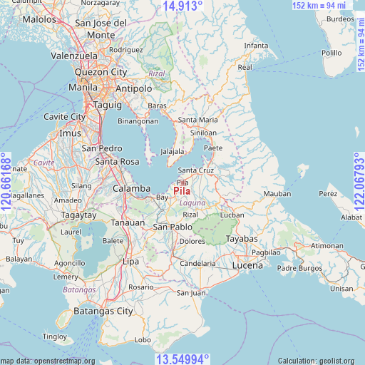
Pila GPS coordinates[2]
14° 13' 57" North, 121° 21' 53.28" East
| Map corner | latitude | longitude |
|---|---|---|
| Upper-left | 14.913°, | 120.66168° |
| Center: | 14.2325°, | 121.3648° |
| Lower-right: | 13.54994°, | 122.06793° |
| Map W x H: | 151.6×151.6 km | = 94.2×94.2mi |
| max Lat: | 20.78733° ⇑27.8% North |
| Pila: | 14.2325° |
| min Lat: | ⇓72.2% South 4.65442° |
| min Long | Pila | max Long |
| 117.04868° | 121.3648° | 126.58417° |
| W 30.8%⇐ | ⇒69.2% E |
Elevation
Elevation of Pila is 14 m = 46 ft, and this is 73.9 m = 242 ft below average elevation for this country.
| Max E: |
2262 m = 7421 ft | 65.1% |
| Avg. | 87.9 m = 288 ft | |
| Pila | 14 m = 46 ft | |
Min E: |
-2 m = -7 ft | 34.9% |
See also: Philippines elevation on elevation.city.
Geographical zone
Pila is located in North Torrid zone (between Equator and Tropic of Cancer). Distance of this Northern Tropic circle is 1023.4 km =635.9 mi to North.| Distance of | km | miles | from Pila |
|---|---|---|---|
| North Pole | 8424.6 | 5234.8 | to North |
| Arctic Circle | 5818.7 | 3615.6 | to North |
| Tropic Cancer | 1023.4 | 635.9 | to North |
| Equator | 1582.5 | 983.3 | to South |


Nearby cities:
15 places around Pila: (largest is in red/bold)
• Bay
10.1 km =6.3 mi,  237°
237°
• Cabanbanan
7.5 km =4.7 mi,  83°
83°
• Calumpang
5.7 km =3.5 mi,  134°
134°
• Cigaras
7 km =4.3 mi,  95°
95°
• Dayap
6.7 km =4.2 mi,  210°
210°
• Halayhayin
6.7 km =4.2 mi,  136°
136°
• Hanggan
8.5 km =5.3 mi, 235°
• Magdalena
7.8 km =4.8 mi,  117°
117°
• Masapang
4.6 km =2.9 mi, 211°
• Maulawin
8.3 km =5.2 mi,  62°
62°
• Punta
9 km =5.6 mi,  316°
316°
• San Isidro
4.5 km =2.8 mi, 126°
• San Miguel
3.6 km =2.2 mi,  165°
165°
• Santa Cruz
7.8 km =4.8 mi,  45°
45°
• Victoria
3.9 km =2.4 mi,  262°
262°
Sources, notices
• [Note1] Compared only with cities in Philippines existing in our database
• [Src1] Map data: © OpenStreetMap contributors (CC-BY-SA)
• [Src2] Other city data from geonames.org with taken over terms of usage.
• [Src3] Geographical zone / Annual Mean Temperature by Robert A. Rohde @ Wikipedia
