Mainit Norte geodata
Mainit Norte (Calabarzon) is a populated place; located in Philippines in Asia/Manila (GMT+8) time zone. With population of 2,442 people, there are 3396 cities with bigger population in this country. Compared to other cities in Philippines, 71.3% of cities are located further ↓South; 60.4% of cities are located further →East and 74.9% of cities have lower elevation than Mainit Norte. Note1


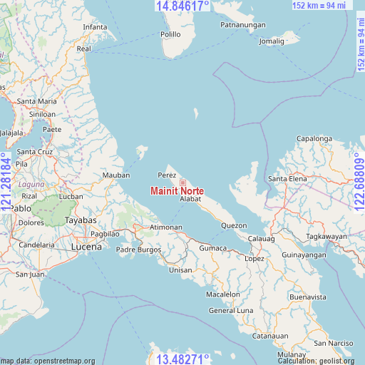
Mainit Norte GPS coordinates[2]
14° 9' 55.656" North, 121° 59' 5.856" East
| Map corner | latitude | longitude |
|---|---|---|
| Upper-left | 14.84617°, | 121.28184° |
| Center: | 14.16546°, | 121.98496° |
| Lower-right: | 13.48271°, | 122.68809° |
| Map W x H: | 151.6×151.6 km | = 94.2×94.2mi |
| max Lat: | 20.78733° ⇑28.7% North |
| Mainit Norte: | 14.16546° |
| min Lat: | ⇓71.3% South 4.65442° |
| min Long | Mainit Norte | max Long |
| 117.04868° | 121.98496° | 126.58417° |
| W 39.6%⇐ | ⇒60.4% E |
Elevation
Elevation of Mainit Norte is 68 m = 223 ft, and this is 19.9 m = 65 ft below average elevation for this country.
| Max E: |
2262 m = 7421 ft | 25.1% |
| Avg. | 87.9 m = 288 ft | |
| Mainit Norte | 68 m = 223 ft | |
Min E: |
-2 m = -7 ft | 74.9% |
See also: Philippines elevation on elevation.city.
Geographical zone
Mainit Norte is located in North Torrid zone (between Equator and Tropic of Cancer). Distance of this Northern Tropic circle is 1030.9 km =640.6 mi to North.| Distance of | km | miles | from Mainit Norte |
|---|---|---|---|
| North Pole | 8432 | 5239.4 | to North |
| Arctic Circle | 5826.1 | 3620.2 | to North |
| Tropic Cancer | 1030.9 | 640.6 | to North |
| Equator | 1575.1 | 978.7 | to South |


Nearby cities:
15 places around Mainit Norte: (largest is in red/bold)
• Alabat
7.8 km =4.8 mi,  157°
157°
• Atimonan
19.4 km =12.1 mi,  200°
200°
• Binahaan
31.5 km =19.6 mi,  232°
232°
• Cagsiay
26 km =16.2 mi,  282°
282°
• Gumaca
29.9 km =18.6 mi, 155°
• Malicboy
29.4 km =18.3 mi, 225°
• Malinao Ilaya
24.8 km =15.4 mi,  220°
220°
• Mauban
27.5 km =17.1 mi, 275°
• Padre Burgos
32.8 km =20.4 mi,  214°
214°
• Panikihan
32.6 km =20.3 mi,  151°
151°
• Perez
7.1 km =4.4 mi,  297°
297°
• Plaridel
23.7 km =14.7 mi,  170°
170°
• Progreso
30.8 km =19.1 mi, 158°
• Quezon
27.8 km =17.3 mi,  129°
129°
• Santa Cecilia
24.3 km =15.1 mi,  105°
105°
Sources, notices
• [Note1] Compared only with cities in Philippines existing in our database
• [Src1] Map data: © OpenStreetMap contributors (CC-BY-SA)
• [Src2] Other city data from geonames.org with taken over terms of usage.
• [Src3] Geographical zone / Annual Mean Temperature by Robert A. Rohde @ Wikipedia
